Orahovica geodata
Orahovica (Virovitičk-Podravska) is a seat of a second-order administrative division; located in Croatia in Europe/Zagreb (GMT+2) time zone. With population of 4,283 people, there are 95 cities with bigger population in this country. Compared to other cities in Croatia, 56% of cities are located further ↓South; 80.5% of cities are located further ←West and 71.7% of cities have lower elevation than Orahovica. Note1


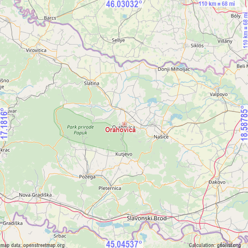
Orahovica GPS coordinates[2]
45° 32' 24" North, 17° 53' 4.992" East
| Map corner | latitude | longitude |
|---|---|---|
| Upper-left | 46.03032°, | 17.1816° |
| Center: | 45.54°, | 17.88472° |
| Lower-right: | 45.04537°, | 18.58785° |
| Map W x H: | 109.5×109.5 km | = 68×68mi |
| max Lat: | 46.52694° ⇑44% North |
| Orahovica: | 45.54° |
| min Lat: | ⇓56% South 42.54972° |
| min Long | Orahovica | max Long |
| 13.52389° | 17.88472° | 19.37694° |
| W 80.5%⇐ | ⇒19.5% E |
Elevation
Elevation of Orahovica is 171 m = 561 ft, and this is 17.7 m = 58 ft above average elevation for this country.
| Max E: |
827 m = 2713 ft | 28.3% |
| Orahovica | 171 m 561 ft | |
| Avg. | 153.3 m = 503 ft | |
Min E: |
-1 m = -3 ft | 71.7% |
See also: Croatia elevation on elevation.city.
Geographical zone
Orahovica is located in North temperate zone (between Tropic of Cancer and the Arctic Circle). Distance of this North polar circle is 2337.6 km =1452.5 mi to North.| Distance of | km | miles | from Orahovica |
|---|---|---|---|
| North Pole | 4943.5 | 3071.7 | to North |
| Arctic Circle | 2337.6 | 1452.5 | to North |
| Tropic Cancer | 2457.7 | 1527.1 | to South |
| Equator | 5063.6 | 3146.4 | to South |


Nearby cities:
15 places around Orahovica: (largest is in red/bold)
• Beljevina
10.4 km =6.5 mi,  74°
74°
• Donja Motičina
12 km =7.5 mi,  114°
114°
• Feričanci
7.2 km =4.5 mi,  99°
99°
• Kaptol
17 km =10.6 mi,  226°
226°
• Kutjevo
12.7 km =7.9 mi,  180°
180°
• Martin
15.1 km =9.4 mi, 110°
• Mikleuš
10.8 km =6.7 mi,  324°
324°
• Našice
16.8 km =10.4 mi, 109°
• Nova Bukovica
16.6 km =10.3 mi,  326°
326°
• Velimirovac
17.6 km =10.9 mi, 95°
• Vetovo
15.5 km =9.6 mi,  207°
207°
• Zdenci
7.5 km =4.7 mi,  43°
43°
• Ðurđenovac
12.6 km =7.8 mi,  88°
88°
• Čačinci
7.2 km =4.5 mi,  351°
351°
• Šaptinovci
14.3 km =8.9 mi, 72°
Sources, notices
• [Note1] Compared only with cities in Croatia existing in our database
• [Src1] Map data: © OpenStreetMap contributors (CC-BY-SA)
• [Src2] Other city data from geonames.org with taken over terms of usage.
• [Src3] Geographical zone / Annual Mean Temperature by Robert A. Rohde @ Wikipedia
