Oborovo geodata
Oborovo (Zagrebačka) is a populated place; located in Croatia in Europe/Zagreb (GMT+2) time zone. With population of 662 people, there are 704 cities with bigger population in this country. Compared to other cities in Croatia, 63.4% of cities are located further ↓South; 59.2% of cities are located further →East and 68.8% of cities have higher elevation than Oborovo. Note1


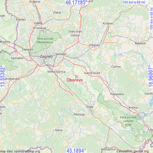
Oborovo GPS coordinates[2]
45° 40' 58.008" North, 16° 15' 24.984" East
| Map corner | latitude | longitude |
|---|---|---|
| Upper-left | 46.17185°, | 15.55382° |
| Center: | 45.68278°, | 16.25694° |
| Lower-right: | 45.1894°, | 16.96007° |
| Map W x H: | 109.2×109.2 km | = 67.9×67.9mi |
| max Lat: | 46.52694° ⇑36.6% North |
| Oborovo: | 45.68278° |
| min Lat: | ⇓63.4% South 42.54972° |
| min Long | Oborovo | max Long |
| 13.52389° | 16.25694° | 19.37694° |
| W 40.8%⇐ | ⇒59.2% E |
Elevation
Elevation of Oborovo is 97 m = 318 ft, and this is 56.3 m = 185 ft below average elevation for this country.
| Max E: |
827 m = 2713 ft | 68.8% |
| Avg. | 153.3 m = 503 ft | |
| Oborovo | 97 m = 318 ft | |
Min E: |
-1 m = -3 ft | 31.2% |
See also: Croatia elevation on elevation.city.
Geographical zone
Oborovo is located in North temperate zone (between Tropic of Cancer and the Arctic Circle). Distance of this North polar circle is 2321.7 km =1442.6 mi to North.| Distance of | km | miles | from Oborovo |
|---|---|---|---|
| North Pole | 4927.6 | 3061.9 | to North |
| Arctic Circle | 2321.7 | 1442.6 | to North |
| Tropic Cancer | 2473.5 | 1537 | to South |
| Equator | 5079.4 | 3156.2 | to South |


Nearby cities:
15 places around Oborovo: (largest is in red/bold)
• Ivanić-Grad
11.2 km =7 mi,  75°
75°
• Jagodno
8.5 km =5.3 mi,  282°
282°
• Jalševec Nartski
10 km =6.2 mi,  334°
334°
• Kuče
8.7 km =5.4 mi,  265°
265°
• Novo Čiče
11.1 km =6.9 mi, 279°
• Orle
1.8 km =1.1 mi, 271°
• Poljana Čička
6 km =3.7 mi, 270°
• Posavski Bregi
7.5 km =4.7 mi,  92°
92°
• Rakitovec
8.5 km =5.3 mi,  257°
257°
• Ribnica
10.3 km =6.4 mi,  291°
291°
• Rugvica
6.2 km =3.9 mi,  342°
342°
• Staro Čiče
11.1 km =6.9 mi, 279°
• Struga Nartska
10.2 km =6.3 mi, 331°
• Turopolje
9.6 km =6 mi,  247°
247°
• Vukovina
10.9 km =6.8 mi, 270°
Sources, notices
• [Note1] Compared only with cities in Croatia existing in our database
• [Src1] Map data: © OpenStreetMap contributors (CC-BY-SA)
• [Src2] Other city data from geonames.org with taken over terms of usage.
• [Src3] Geographical zone / Annual Mean Temperature by Robert A. Rohde @ Wikipedia
