Cerić geodata
Cerić (Vukovar-Sirmium) is a populated place; located in Croatia in Europe/Zagreb (GMT+2) time zone. With population of 1,458 people, there are 310 cities with bigger population in this country. Compared to other cities in Croatia, 58.9% of cities are located further ↑North; 97% of cities are located further ←West and 68.2% of cities have higher elevation than Cerić. Note1


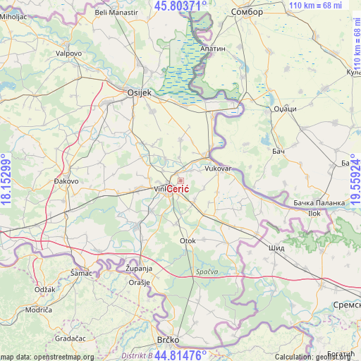
Cerić GPS coordinates[2]
45° 18' 41.004" North, 18° 51' 21.996" East
| Map corner | latitude | longitude |
|---|---|---|
| Upper-left | 45.80371°, | 18.15299° |
| Center: | 45.31139°, | 18.85611° |
| Lower-right: | 44.81476°, | 19.55924° |
| Map W x H: | 110×110 km | = 68.4×68.4mi |
| max Lat: | 46.52694° ⇑58.9% North |
| Cerić: | 45.31139° |
| min Lat: | ⇓41.1% South 42.54972° |
| min Long | Cerić | max Long |
| 13.52389° | 18.85611° | 19.37694° |
| W 97%⇐ | ⇒3% E |
Elevation
Elevation of Cerić is 98 m = 322 ft, and this is 55.3 m = 181 ft below average elevation for this country.
| Max E: |
827 m = 2713 ft | 68.2% |
| Avg. | 153.3 m = 503 ft | |
| Cerić | 98 m = 322 ft | |
Min E: |
-1 m = -3 ft | 31.8% |
See also: Croatia elevation on elevation.city.
Geographical zone
Cerić is located in North temperate zone (between Tropic of Cancer and the Arctic Circle). Distance of this North polar circle is 2363 km =1468.3 mi to North.| Distance of | km | miles | from Cerić |
|---|---|---|---|
| North Pole | 4968.9 | 3087.5 | to North |
| Arctic Circle | 2363 | 1468.3 | to North |
| Tropic Cancer | 2432.2 | 1511.3 | to South |
| Equator | 5038.2 | 3130.6 | to South |


Nearby cities:
15 places around Cerić: (largest is in red/bold)
• Bogdanovci
6.7 km =4.2 mi,  60°
60°
• Bršadin
7.2 km =4.5 mi,  36°
36°
• Gaboš
10.5 km =6.5 mi,  296°
296°
• Jarmina
10 km =6.2 mi,  274°
274°
• Marinci
4.6 km =2.9 mi,  46°
46°
• Mirkovci
4.6 km =2.9 mi,  184°
184°
• Novi Jankovci
8.5 km =5.3 mi,  158°
158°
• Nuštar
2.6 km =1.6 mi,  333°
333°
• Ostrovo
6.1 km =3.8 mi, 302°
• Pačetin
6.8 km =4.2 mi,  354°
354°
• Petrovcy
7.3 km =4.5 mi,  109°
109°
• Srijemske Laze
10.8 km =6.7 mi,  146°
146°
• Stari Jankovci
7.1 km =4.4 mi,  140°
140°
• Tordinci
8.1 km =5 mi,  323°
323°
• Vinkovci
4.8 km =3 mi,  237°
237°
Sources, notices
• [Note1] Compared only with cities in Croatia existing in our database
• [Src1] Map data: © OpenStreetMap contributors (CC-BY-SA)
• [Src2] Other city data from geonames.org with taken over terms of usage.
• [Src3] Geographical zone / Annual Mean Temperature by Robert A. Rohde @ Wikipedia
