Srijemske Laze geodata
Srijemske Laze (Vukovar-Sirmium) is a populated place; located in Croatia in Europe/Zagreb (GMT+2) time zone. With population of 572 people, there are 781 cities with bigger population in this country. Compared to other cities in Croatia, 64.6% of cities are located further ↑North; 98% of cities are located further ←West and 71% of cities have higher elevation than Srijemske Laze. Note1


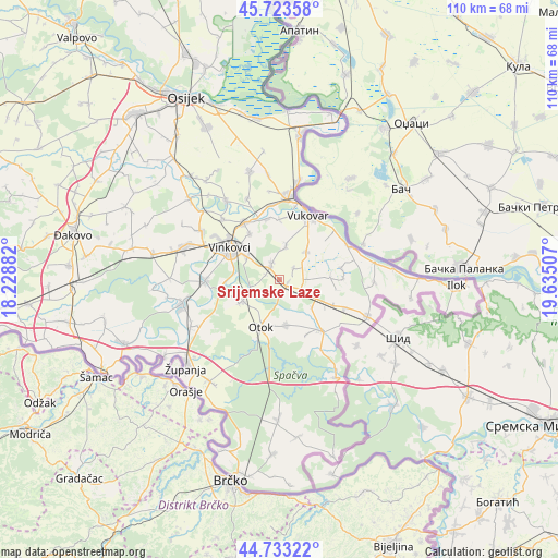
Srijemske Laze GPS coordinates[2]
45° 13' 50.016" North, 18° 55' 54.984" East
| Map corner | latitude | longitude |
|---|---|---|
| Upper-left | 45.72358°, | 18.22882° |
| Center: | 45.23056°, | 18.93194° |
| Lower-right: | 44.73322°, | 19.63507° |
| Map W x H: | 110.1×110.1 km | = 68.4×68.4mi |
| max Lat: | 46.52694° ⇑64.6% North |
| Srijemske Laze: | 45.23056° |
| min Lat: | ⇓35.4% South 42.54972° |
| min Long | Srijemske Laze | max Long |
| 13.52389° | 18.93194° | 19.37694° |
| W 98%⇐ | ⇒2% E |
Elevation
Elevation of Srijemske Laze is 93 m = 305 ft, and this is 60.3 m = 198 ft below average elevation for this country.
| Max E: |
827 m = 2713 ft | 71% |
| Avg. | 153.3 m = 503 ft | |
| Srijemske Laze | 93 m = 305 ft | |
Min E: |
-1 m = -3 ft | 29% |
See also: Croatia elevation on elevation.city.
Geographical zone
Srijemske Laze is located in North temperate zone (between Tropic of Cancer and the Arctic Circle). Distance of this North polar circle is 2372 km =1473.9 mi to North.| Distance of | km | miles | from Srijemske Laze |
|---|---|---|---|
| North Pole | 4977.9 | 3093.1 | to North |
| Arctic Circle | 2372 | 1473.9 | to North |
| Tropic Cancer | 2423.2 | 1505.7 | to South |
| Equator | 5029.2 | 3125 | to South |


Nearby cities:
15 places around Srijemske Laze: (largest is in red/bold)
• Bogdanovci
12.3 km =7.6 mi,  359°
359°
• Cerić
10.8 km =6.7 mi,  326°
326°
• Komletinci
9.1 km =5.7 mi,  171°
171°
• Marinci
12.4 km =7.7 mi,  348°
348°
• Mirkovci
7.7 km =4.8 mi,  304°
304°
• Negoslavci
7.4 km =4.6 mi,  42°
42°
• Novi Jankovci
3 km =1.9 mi,  290°
290°
• Orolik
4.5 km =2.8 mi,  112°
112°
• Otok
10.1 km =6.3 mi,  201°
201°
• Petrovcy
6.6 km =4.1 mi,  8°
8°
• Privlaka
8.4 km =5.2 mi,  241°
241°
• Slakovci
1.6 km =1 mi, 114°
• Stari Jankovci
3.7 km =2.3 mi,  338°
338°
• Tompojevci
12.5 km =7.8 mi,  88°
88°
• Vinkovci
11.8 km =7.3 mi, 302°
Sources, notices
• [Note1] Compared only with cities in Croatia existing in our database
• [Src1] Map data: © OpenStreetMap contributors (CC-BY-SA)
• [Src2] Other city data from geonames.org with taken over terms of usage.
• [Src3] Geographical zone / Annual Mean Temperature by Robert A. Rohde @ Wikipedia
