Brezovica geodata
Brezovica (City of Zagreb) is a populated place; located in Croatia in Europe/Zagreb (GMT+2) time zone. With population of 10,884 people, there are 40 cities with bigger population in this country. Compared to other cities in Croatia, 67.1% of cities are located further ↓South; 71.5% of cities are located further →East and 54.4% of cities have higher elevation than Brezovica. Note1


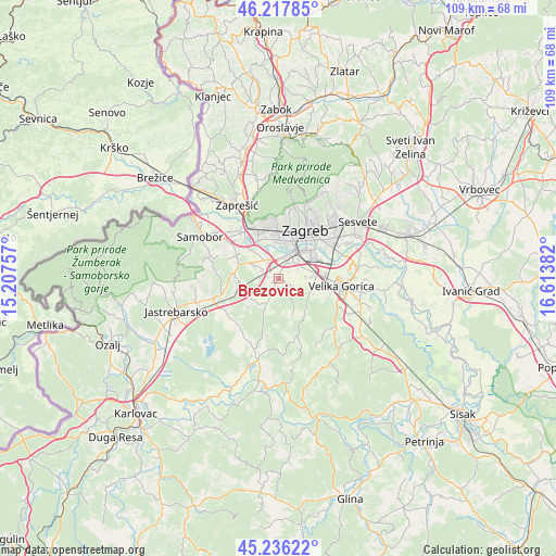
Brezovica GPS coordinates[2]
45° 43' 45.084" North, 15° 54' 38.484" East
| Map corner | latitude | longitude |
|---|---|---|
| Upper-left | 46.21785°, | 15.20757° |
| Center: | 45.72919°, | 15.91069° |
| Lower-right: | 45.23622°, | 16.61382° |
| Map W x H: | 109.1×109.1 km | = 67.8×67.8mi |
| max Lat: | 46.52694° ⇑32.9% North |
| Brezovica: | 45.72919° |
| min Lat: | ⇓67.1% South 42.54972° |
| min Long | Brezovica | max Long |
| 13.52389° | 15.91069° | 19.37694° |
| W 28.5%⇐ | ⇒71.5% E |
Elevation
Elevation of Brezovica is 118 m = 387 ft, and this is 35.3 m = 116 ft below average elevation for this country.
| Max E: |
827 m = 2713 ft | 54.4% |
| Avg. | 153.3 m = 503 ft | |
| Brezovica | 118 m = 387 ft | |
Min E: |
-1 m = -3 ft | 45.6% |
See also: Croatia elevation on elevation.city.
Geographical zone
Brezovica is located in North temperate zone (between Tropic of Cancer and the Arctic Circle). Distance of this North polar circle is 2316.6 km =1439.5 mi to North.| Distance of | km | miles | from Brezovica |
|---|---|---|---|
| North Pole | 4922.5 | 3058.7 | to North |
| Arctic Circle | 2316.6 | 1439.5 | to North |
| Tropic Cancer | 2478.7 | 1540.2 | to South |
| Equator | 5084.6 | 3159.4 | to South |


Nearby cities:
15 places around Brezovica: (largest is in red/bold)
• Donja Lomnica
9.2 km =5.7 mi,  101°
101°
• Donji Stupnik
4.1 km =2.5 mi,  286°
286°
• Gornja Lomnica
7.1 km =4.4 mi, 101°
• Horvati
8 km =5 mi,  246°
246°
• Jankomir
7 km =4.3 mi,  353°
353°
• Ježdovec
7.6 km =4.7 mi,  321°
321°
• Kerestinec
9.1 km =5.7 mi,  299°
299°
• Lukavec
6.7 km =4.2 mi,  114°
114°
• Lučko
4.7 km =2.9 mi, 318°
• Novi Zagreb
8.2 km =5.1 mi,  43°
43°
• Odra
6.3 km =3.9 mi,  89°
89°
• Rakov Potok
8.9 km =5.5 mi,  276°
276°
• Stenjevec
9.1 km =5.7 mi, 346°
• Strmec
2.4 km =1.5 mi,  168°
168°
• Zadvorsko
1.1 km =0.7 mi,  187°
187°
Sources, notices
• [Note1] Compared only with cities in Croatia existing in our database
• [Src1] Map data: © OpenStreetMap contributors (CC-BY-SA)
• [Src2] Other city data from geonames.org with taken over terms of usage.
• [Src3] Geographical zone / Annual Mean Temperature by Robert A. Rohde @ Wikipedia
