Zugló geodata
Zugló (Budapest) is a section of populated place; located in Hungary in Europe/Budapest (GMT+2) time zone. With population of 130,000 people, there are 6 cities with bigger population in this country. Compared to other cities in Hungary, 56.9% of cities are located further ↓South; 59.6% of cities are located further →East and 58.1% of cities have higher elevation than Zugló. Note1


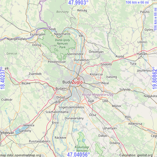
Zugló GPS coordinates[2]
47° 31' 3.288" North, 19° 6' 19.764" East
| Map corner | latitude | longitude |
|---|---|---|
| Upper-left | 47.9903°, | 18.40237° |
| Center: | 47.51758°, | 19.10549° |
| Lower-right: | 47.04056°, | 19.80862° |
| Map W x H: | 105.6×105.6 km | = 65.6×65.6mi |
| max Lat: | 48.46667° ⇑43.1% North |
| Zugló: | 47.51758° |
| min Lat: | ⇓56.9% South 45.79108° |
| min Long | Zugló | max Long |
| 16.27358° | 19.10549° | 22.68096° |
| W 40.4%⇐ | ⇒59.6% E |
Elevation
Elevation of Zugló is 111 m = 364 ft, and this is 18.7 m = 61 ft below average elevation for this country.
| Max E: |
444 m = 1457 ft | 58.1% |
| Avg. | 129.7 m = 426 ft | |
| Zugló | 111 m = 364 ft | |
Min E: |
71 m = 233 ft | 41.9% |
See also: Zugló elevation on elevation.city.
Geographical zone
Zugló is located in North temperate zone (between Tropic of Cancer and the Arctic Circle). Distance of this North polar circle is 2117.7 km =1315.9 mi to North.| Distance of | km | miles | from Zugló |
|---|---|---|---|
| North Pole | 4723.6 | 2935.1 | to North |
| Arctic Circle | 2117.7 | 1315.9 | to North |
| Tropic Cancer | 2677.5 | 1663.7 | to South |
| Equator | 5283.5 | 3283 | to South |


Nearby cities:
15 places around Zugló: (largest is in red/bold)
• Budapest
5.3 km =3.3 mi,  246°
246°
• Budapest I. kerület
5.4 km =3.4 mi, 245°
• Budapest II. kerület
6.3 km =3.9 mi,  272°
272°
• Budapest III. kerület
5.3 km =3.3 mi,  300°
300°
• Budapest IV. kerület
5.1 km =3.2 mi,  345°
345°
• Budapest VI. kerület
3.4 km =2.1 mi,  242°
242°
• Budapest VIII. kerület
4.1 km =2.5 mi,  220°
220°
• Budapest X. kerület
5.8 km =3.6 mi,  137°
137°
• Budapest XI. kerület
7 km =4.3 mi,  228°
228°
• Budapest XII. kerület
7.4 km =4.6 mi, 247°
• Budapest XIII. kerület
2.3 km =1.4 mi,  306°
306°
• Budapest XV. kerület
5.1 km =3.2 mi,  9°
9°
• Budapest XVI. kerület
4.9 km =3 mi,  93°
93°
• Erzsébetváros
3 km =1.9 mi, 235°
• Józsefváros
4 km =2.5 mi, 217°
In other languages:
- In France: 14e arrondissement de Budapest
- In German: Lerchenfeld
- In Chinese: 布达佩斯第十四区
Sources, notices
• [Note1] Compared only with cities in Hungary existing in our database
• [Src1] Map data: © OpenStreetMap contributors (CC-BY-SA)
• [Src2] Other city data from geonames.org with taken over terms of usage.
• [Src3] Geographical zone / Annual Mean Temperature by Robert A. Rohde @ Wikipedia
