Budapest geodata
Budapest is a capital of a political entity; located in Hungary in Europe/Budapest (GMT+2) time zone. With population of 1,741,041 people, there are 0 cities with bigger population in this country. Compared to other cities in Hungary, 55.5% of cities are located further ↓South; 62.3% of cities are located further →East and 99.8% of cities have higher elevation than Budapest. Note1


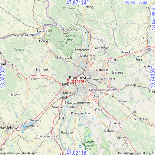
Budapest GPS coordinates[2]
47° 29' 54.06" North, 19° 2' 25.62" East
| Map corner | latitude | longitude |
|---|---|---|
| Upper-left | 47.97124°, | 18.33733° |
| Center: | 47.49835°, | 19.04045° |
| Lower-right: | 47.02116°, | 19.74358° |
| Map W x H: | 105.6×105.6 km | = 65.6×65.6mi |
| max Lat: | 48.46667° ⇑44.5% North |
| Budapest: | 47.49835° |
| min Lat: | ⇓55.5% South 45.79108° |
| min Long | Budapest | max Long |
| 16.27358° | 19.04045° | 22.68096° |
| W 37.7%⇐ | ⇒62.3% E |
Elevation
Elevation of Budapest is 75 m = 246 ft, and this is 54.7 m = 179 ft below average elevation for this country.
| Max E: |
444 m = 1457 ft | 99.8% |
| Avg. | 129.7 m = 426 ft | |
| Budapest | 75 m = 246 ft | |
Min E: |
71 m = 233 ft | 0.2% |
See also: Budapest elevation on elevation.city.
Geographical zone
Budapest is located in North temperate zone (between Tropic of Cancer and the Arctic Circle). Distance of this North polar circle is 2119.9 km =1317.2 mi to North.| Distance of | km | miles | from Budapest |
|---|---|---|---|
| North Pole | 4725.7 | 2936.4 | to North |
| Arctic Circle | 2119.9 | 1317.2 | to North |
| Tropic Cancer | 2675.4 | 1662.4 | to South |
| Equator | 5281.3 | 3281.6 | to South |


Nearby cities:
15 places around Budapest: (largest is in red/bold)
• Budapest I. kerület
0.2 km =0.1 mi,  203°
203°
• Budapest II. kerület
2.8 km =1.7 mi,  330°
330°
• Budapest III. kerület
4.8 km =3 mi,  4°
4°
• Budapest IV. kerület
7.9 km =4.9 mi,  27°
27°
• Budapest VI. kerület
2 km =1.2 mi,  72°
72°
• Budapest VIII. kerület
2.5 km =1.6 mi,  114°
114°
• Budapest XI. kerület
2.5 km =1.6 mi,  187°
187°
• Budapest XII. kerület
2 km =1.2 mi,  249°
249°
• Budapest XIII. kerület
4.6 km =2.9 mi,  40°
40°
• Budapest XXI. kerület
7.9 km =4.9 mi,  163°
163°
• Budapest XXII. kerület
7.9 km =4.9 mi,  180°
180°
• Budaörs
7.4 km =4.6 mi,  236°
236°
• Erzsébetváros
2.4 km =1.5 mi,  80°
80°
• Józsefváros
2.6 km =1.6 mi, 112°
• Zugló
5.3 km =3.3 mi, 66°
Sources, notices
• [Note1] Compared only with cities in Hungary existing in our database
• [Src1] Map data: © OpenStreetMap contributors (CC-BY-SA)
• [Src2] Other city data from geonames.org with taken over terms of usage.
• [Src3] Geographical zone / Annual Mean Temperature by Robert A. Rohde @ Wikipedia
