Kispest geodata
Kispest (Budapest) is a section of populated place; located in Hungary in Europe/Budapest (GMT+2) time zone. With population of 61,453 people, there are 35 cities with bigger population in this country. Compared to other cities in Hungary, 52.7% of cities are located further ↓South; 58.5% of cities are located further →East and 50.8% of cities have higher elevation than Kispest. Note1


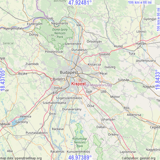
Kispest GPS coordinates[2]
47° 27' 5.4" North, 19° 8' 24.612" East
| Map corner | latitude | longitude |
|---|---|---|
| Upper-left | 47.92481°, | 18.43705° |
| Center: | 47.4515°, | 19.14017° |
| Lower-right: | 46.97389°, | 19.8433° |
| Map W x H: | 105.7×105.7 km | = 65.7×65.7mi |
| max Lat: | 48.46667° ⇑47.3% North |
| Kispest: | 47.4515° |
| min Lat: | ⇓52.7% South 45.79108° |
| min Long | Kispest | max Long |
| 16.27358° | 19.14017° | 22.68096° |
| W 41.5%⇐ | ⇒58.5% E |
Elevation
Elevation of Kispest is 115 m = 377 ft, and this is 14.7 m = 48 ft below average elevation for this country.
| Max E: |
444 m = 1457 ft | 50.8% |
| Avg. | 129.7 m = 426 ft | |
| Kispest | 115 m = 377 ft | |
Min E: |
71 m = 233 ft | 49.2% |
See also: Kispest elevation on elevation.city.
Geographical zone
Kispest is located in North temperate zone (between Tropic of Cancer and the Arctic Circle). Distance of this North polar circle is 2125.1 km =1320.5 mi to North.| Distance of | km | miles | from Kispest |
|---|---|---|---|
| North Pole | 4730.9 | 2939.6 | to North |
| Arctic Circle | 2125.1 | 1320.5 | to North |
| Tropic Cancer | 2670.2 | 1659.2 | to South |
| Equator | 5276.1 | 3278.4 | to South |


Nearby cities:
15 places around Kispest: (largest is in red/bold)
• Budapest VI. kerület
8.1 km =5 mi,  316°
316°
• Budapest VIII. kerület
6.7 km =4.2 mi,  308°
308°
• Budapest X. kerület
3.4 km =2.1 mi,  24°
24°
• Budapest XI. kerület
8.3 km =5.2 mi,  289°
289°
• Budapest XIX. kerület
0.7 km =0.4 mi,  77°
77°
• Budapest XVI. kerület
7.4 km =4.6 mi, 17°
• Budapest XVII. kerület
9.1 km =5.7 mi,  69°
69°
• Budapest XVIII. kerület
2.8 km =1.7 mi,  106°
106°
• Budapest XX. kerület
3.4 km =2.1 mi,  240°
240°
• Budapest XXI. kerület
5.7 km =3.5 mi,  245°
245°
• Budapest XXII. kerület
8 km =5 mi, 250°
• Budapest XXIII. kerület
6.3 km =3.9 mi,  197°
197°
• Erzsébetváros
7.6 km =4.7 mi, 317°
• Józsefváros
6.6 km =4.1 mi, 309°
• Zugló
7.8 km =4.8 mi,  340°
340°
Sources, notices
• [Note1] Compared only with cities in Hungary existing in our database
• [Src1] Map data: © OpenStreetMap contributors (CC-BY-SA)
• [Src2] Other city data from geonames.org with taken over terms of usage.
• [Src3] Geographical zone / Annual Mean Temperature by Robert A. Rohde @ Wikipedia
