Tiszaeszlár geodata
Tiszaeszlár (Szabolcs-Szatmár-Bereg) is a populated place; located in Hungary in Europe/Budapest (GMT+2) time zone. With population of 2,857 people, there are 523 cities with bigger population in this country. Compared to other cities in Hungary, 89.1% of cities are located further ↓South; 87.8% of cities are located further ←West and 80.4% of cities have higher elevation than Tiszaeszlár. Note1


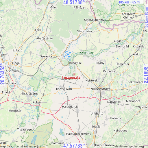
Tiszaeszlár GPS coordinates[2]
48° 3' 0" North, 21° 28' 0.012" East
| Map corner | latitude | longitude |
|---|---|---|
| Upper-left | 48.51788°, | 20.76355° |
| Center: | 48.05°, | 21.46667° |
| Lower-right: | 47.57783°, | 22.1698° |
| Map W x H: | 104.5×104.5 km | = 64.9×64.9mi |
| max Lat: | 48.46667° ⇑10.9% North |
| Tiszaeszlár: | 48.05° |
| min Lat: | ⇓89.1% South 45.79108° |
| min Long | Tiszaeszlár | max Long |
| 16.27358° | 21.46667° | 22.68096° |
| W 87.8%⇐ | ⇒12.2% E |
Elevation
Elevation of Tiszaeszlár is 95 m = 312 ft, and this is 34.7 m = 114 ft below average elevation for this country.
| Max E: |
444 m = 1457 ft | 80.4% |
| Avg. | 129.7 m = 426 ft | |
| Tiszaeszlár | 95 m = 312 ft | |
Min E: |
71 m = 233 ft | 19.6% |
See also: Hungary elevation on elevation.city.
Geographical zone
Tiszaeszlár is located in North temperate zone (between Tropic of Cancer and the Arctic Circle). Distance of this North polar circle is 2058.5 km =1279.1 mi to North.| Distance of | km | miles | from Tiszaeszlár |
|---|---|---|---|
| North Pole | 4664.4 | 2898.3 | to North |
| Arctic Circle | 2058.5 | 1279.1 | to North |
| Tropic Cancer | 2736.7 | 1700.5 | to South |
| Equator | 5342.7 | 3319.8 | to South |


Nearby cities:
15 places around Tiszaeszlár: (largest is in red/bold)
• Buj
14.7 km =9.1 mi,  67°
67°
• Ibrány
19.8 km =12.3 mi, 65°
• Kótaj
18.6 km =11.6 mi,  90°
90°
• Mezőzombor
18.6 km =11.6 mi,  306°
306°
• Nagycserkesz
10.5 km =6.5 mi,  151°
151°
• Nyírtelek
12.9 km =8 mi,  106°
106°
• Prügy
16.5 km =10.3 mi,  282°
282°
• Rakamaz
8.2 km =5.1 mi,  358°
358°
• Tarcal
12.7 km =7.9 mi,  316°
316°
• Tiszabercel
17.6 km =10.9 mi,  50°
50°
• Tiszadada
16.2 km =10.1 mi,  263°
263°
• Tiszalök
7.2 km =4.5 mi,  239°
239°
• Tiszanagyfalu
5.7 km =3.5 mi,  12°
12°
• Tiszavasvári
12.7 km =7.9 mi,  223°
223°
• Tokaj
8.3 km =5.2 mi,  333°
333°
Sources, notices
• [Note1] Compared only with cities in Hungary existing in our database
• [Src1] Map data: © OpenStreetMap contributors (CC-BY-SA)
• [Src2] Other city data from geonames.org with taken over terms of usage.
• [Src3] Geographical zone / Annual Mean Temperature by Robert A. Rohde @ Wikipedia
