Tiszadada geodata
Tiszadada (Szabolcs-Szatmár-Bereg) is a populated place; located in Hungary in Europe/Budapest (GMT+2) time zone. With population of 2,505 people, there are 616 cities with bigger population in this country. Compared to other cities in Hungary, 88.5% of cities are located further ↓South; 84.9% of cities are located further ←West and 80.4% of cities have higher elevation than Tiszadada. Note1


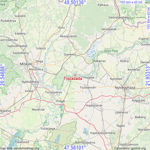
Tiszadada GPS coordinates[2]
48° 1' 59.988" North, 21° 15' 0" East
| Map corner | latitude | longitude |
|---|---|---|
| Upper-left | 48.50136°, | 20.54688° |
| Center: | 48.03333°, | 21.25° |
| Lower-right: | 47.56101°, | 21.95313° |
| Map W x H: | 104.6×104.6 km | = 65×65mi |
| max Lat: | 48.46667° ⇑11.5% North |
| Tiszadada: | 48.03333° |
| min Lat: | ⇓88.5% South 45.79108° |
| min Long | Tiszadada | max Long |
| 16.27358° | 21.25° | 22.68096° |
| W 84.9%⇐ | ⇒15.1% E |
Elevation
Elevation of Tiszadada is 95 m = 312 ft, and this is 34.7 m = 114 ft below average elevation for this country.
| Max E: |
444 m = 1457 ft | 80.4% |
| Avg. | 129.7 m = 426 ft | |
| Tiszadada | 95 m = 312 ft | |
Min E: |
71 m = 233 ft | 19.6% |
See also: Hungary elevation on elevation.city.
Geographical zone
Tiszadada is located in North temperate zone (between Tropic of Cancer and the Arctic Circle). Distance of this North polar circle is 2060.4 km =1280.3 mi to North.| Distance of | km | miles | from Tiszadada |
|---|---|---|---|
| North Pole | 4666.3 | 2899.5 | to North |
| Arctic Circle | 2060.4 | 1280.3 | to North |
| Tropic Cancer | 2734.9 | 1699.4 | to South |
| Equator | 5340.8 | 3318.6 | to South |


Nearby cities:
15 places around Tiszadada: (largest is in red/bold)
• Bekecs
13.9 km =8.6 mi,  339°
339°
• Mezőzombor
13 km =8.1 mi,  5°
5°
• Mád
18.1 km =11.2 mi, 7°
• Prügy
5.6 km =3.5 mi,  0°
0°
• Szerencs
14.4 km =8.9 mi,  347°
347°
• Taktaharkány
10.3 km =6.4 mi,  302°
302°
• Taktaszada
10.5 km =6.5 mi,  331°
331°
• Tarcal
13.4 km =8.3 mi,  33°
33°
• Tiszadob
6.5 km =4 mi,  253°
253°
• Tiszaeszlár
16.2 km =10.1 mi,  83°
83°
• Tiszalök
10.1 km =6.3 mi,  100°
100°
• Tiszalúc
13.2 km =8.2 mi,  272°
272°
• Tiszavasvári
10.5 km =6.5 mi,  134°
134°
• Tiszaújváros
16.7 km =10.4 mi,  228°
228°
• Tokaj
15.5 km =9.6 mi,  53°
53°
Sources, notices
• [Note1] Compared only with cities in Hungary existing in our database
• [Src1] Map data: © OpenStreetMap contributors (CC-BY-SA)
• [Src2] Other city data from geonames.org with taken over terms of usage.
• [Src3] Geographical zone / Annual Mean Temperature by Robert A. Rohde @ Wikipedia
