Nyírvasvári geodata
Nyírvasvári (Szabolcs-Szatmár-Bereg) is a populated place; located in Hungary in Europe/Budapest (GMT+2) time zone. With population of 1,971 people, there are 800 cities with bigger population in this country. Compared to other cities in Hungary, 78.3% of cities are located further ↓South; 97.5% of cities are located further ←West and 75.2% of cities have lower elevation than Nyírvasvári. Note1


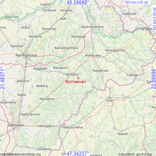
Nyírvasvári GPS coordinates[2]
47° 49' 0.012" North, 22° 11' 12.588" East
| Map corner | latitude | longitude |
|---|---|---|
| Upper-left | 48.28668°, | 21.48371° |
| Center: | 47.81667°, | 22.18683° |
| Lower-right: | 47.34237°, | 22.88996° |
| Map W x H: | 105×105 km | = 65.2×65.2mi |
| max Lat: | 48.46667° ⇑21.7% North |
| Nyírvasvári: | 47.81667° |
| min Lat: | ⇓78.3% South 45.79108° |
| min Long | Nyírvasvári | max Long |
| 16.27358° | 22.18683° | 22.68096° |
| W 97.5%⇐ | ⇒2.5% E |
Elevation
Elevation of Nyírvasvári is 147 m = 482 ft, and this is 17.3 m = 57 ft above average elevation for this country.
| Max E: |
444 m = 1457 ft | 24.8% |
| Nyírvasvári | 147 m 482 ft | |
| Avg. | 129.7 m = 426 ft | |
Min E: |
71 m = 233 ft | 75.2% |
See also: Hungary elevation on elevation.city.
Geographical zone
Nyírvasvári is located in North temperate zone (between Tropic of Cancer and the Arctic Circle). Distance of this North polar circle is 2084.5 km =1295.2 mi to North.| Distance of | km | miles | from Nyírvasvári |
|---|---|---|---|
| North Pole | 4690.3 | 2914.4 | to North |
| Arctic Circle | 2084.5 | 1295.2 | to North |
| Tropic Cancer | 2710.8 | 1684.4 | to South |
| Equator | 5316.7 | 3303.6 | to South |


Nearby cities:
15 places around Nyírvasvári: (largest is in red/bold)
• Bátorliget
8.8 km =5.5 mi,  133°
133°
• Encsencs
10.6 km =6.6 mi,  209°
209°
• Hodász
11.4 km =7.1 mi,  5°
5°
• Kisléta
14 km =8.7 mi,  281°
281°
• Kántorjánosi
13.3 km =8.3 mi,  348°
348°
• Máriapócs
14.2 km =8.8 mi,  301°
301°
• Mérk
14.8 km =9.2 mi,  102°
102°
• Nagyecsed
16.2 km =10.1 mi,  70°
70°
• Nyírbogát
9.2 km =5.7 mi,  260°
260°
• Nyírbátor
4.4 km =2.7 mi,  294°
294°
• Nyírbéltek
13.6 km =8.5 mi,  197°
197°
• Nyírcsaholy
14.8 km =9.2 mi,  49°
49°
• Nyírgyulaj
10.2 km =6.3 mi,  319°
319°
• Nyírmeggyes
12.6 km =7.8 mi,  28°
28°
• Ófehértó
16.5 km =10.3 mi, 321°
Sources, notices
• [Note1] Compared only with cities in Hungary existing in our database
• [Src1] Map data: © OpenStreetMap contributors (CC-BY-SA)
• [Src2] Other city data from geonames.org with taken over terms of usage.
• [Src3] Geographical zone / Annual Mean Temperature by Robert A. Rohde @ Wikipedia
