Encsencs geodata
Encsencs (Szabolcs-Szatmár-Bereg) is a populated place; located in Hungary in Europe/Budapest (GMT+2) time zone. With population of 2,087 people, there are 743 cities with bigger population in this country. Compared to other cities in Hungary, 73.2% of cities are located further ↓South; 96.4% of cities are located further ←West and 78.5% of cities have lower elevation than Encsencs. Note1


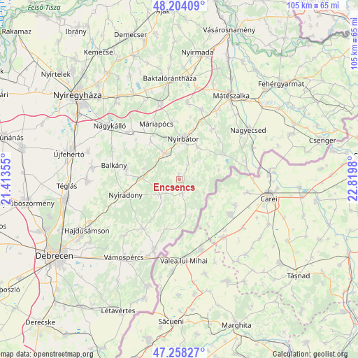
Encsencs GPS coordinates[2]
47° 43' 59.988" North, 22° 7' 0.012" East
| Map corner | latitude | longitude |
|---|---|---|
| Upper-left | 48.20409°, | 21.41355° |
| Center: | 47.73333°, | 22.11667° |
| Lower-right: | 47.25827°, | 22.8198° |
| Map W x H: | 105.2×105.2 km | = 65.4×65.4mi |
| max Lat: | 48.46667° ⇑26.8% North |
| Encsencs: | 47.73333° |
| min Lat: | ⇓73.2% South 45.79108° |
| min Long | Encsencs | max Long |
| 16.27358° | 22.11667° | 22.68096° |
| W 96.4%⇐ | ⇒3.6% E |
Elevation
Elevation of Encsencs is 153 m = 502 ft, and this is 23.3 m = 76 ft above average elevation for this country.
| Max E: |
444 m = 1457 ft | 21.5% |
| Encsencs | 153 m 502 ft | |
| Avg. | 129.7 m = 426 ft | |
Min E: |
71 m = 233 ft | 78.5% |
See also: Hungary elevation on elevation.city.
Geographical zone
Encsencs is located in North temperate zone (between Tropic of Cancer and the Arctic Circle). Distance of this North polar circle is 2093.7 km =1301 mi to North.| Distance of | km | miles | from Encsencs |
|---|---|---|---|
| North Pole | 4699.6 | 2920.2 | to North |
| Arctic Circle | 2093.7 | 1301 | to North |
| Tropic Cancer | 2701.5 | 1678.6 | to South |
| Equator | 5307.4 | 3297.9 | to South |


Nearby cities:
15 places around Encsencs: (largest is in red/bold)
• Balkány
19.4 km =12.1 mi,  282°
282°
• Bátorliget
12.1 km =7.5 mi,  74°
74°
• Kisléta
14.8 km =9.2 mi,  325°
325°
• Kállósemjén
19.4 km =12.1 mi,  316°
316°
• Máriapócs
18 km =11.2 mi,  337°
337°
• Nyíracsád
18.1 km =11.2 mi,  216°
216°
• Nyíradony
15.3 km =9.5 mi,  254°
254°
• Nyírbogát
8.7 km =5.4 mi, 333°
• Nyírbátor
11.2 km =7 mi,  6°
6°
• Nyírbéltek
3.9 km =2.4 mi,  161°
161°
• Nyírgyulaj
17.1 km =10.6 mi,  355°
355°
• Nyírlugos
7 km =4.3 mi,  230°
230°
• Nyírmihálydi
11.4 km =7.1 mi,  273°
273°
• Nyírvasvári
10.6 km =6.6 mi,  29°
29°
• Szakoly
15.4 km =9.6 mi, 283°
Sources, notices
• [Note1] Compared only with cities in Hungary existing in our database
• [Src1] Map data: © OpenStreetMap contributors (CC-BY-SA)
• [Src2] Other city data from geonames.org with taken over terms of usage.
• [Src3] Geographical zone / Annual Mean Temperature by Robert A. Rohde @ Wikipedia
