Mályi geodata
Mályi (Borsod-Abaúj-Zemplén) is a populated place; located in Hungary in Europe/Budapest (GMT+2) time zone. With population of 4,128 people, there are 364 cities with bigger population in this country. Compared to other cities in Hungary, 87.8% of cities are located further ↓South; 77.5% of cities are located further ←West and 67.6% of cities have higher elevation than Mályi. Note1


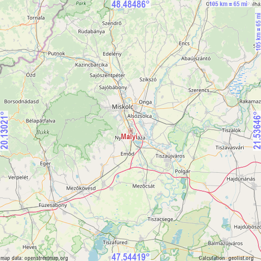
Mályi GPS coordinates[2]
48° 1' 0.012" North, 20° 49' 59.988" East
| Map corner | latitude | longitude |
|---|---|---|
| Upper-left | 48.48486°, | 20.13021° |
| Center: | 48.01667°, | 20.83333° |
| Lower-right: | 47.54419°, | 21.53646° |
| Map W x H: | 104.6×104.6 km | = 65×65mi |
| max Lat: | 48.46667° ⇑12.2% North |
| Mályi: | 48.01667° |
| min Lat: | ⇓87.8% South 45.79108° |
| min Long | Mályi | max Long |
| 16.27358° | 20.83333° | 22.68096° |
| W 77.5%⇐ | ⇒22.5% E |
Elevation
Elevation of Mályi is 104 m = 341 ft, and this is 25.7 m = 84 ft below average elevation for this country.
| Max E: |
444 m = 1457 ft | 67.6% |
| Avg. | 129.7 m = 426 ft | |
| Mályi | 104 m = 341 ft | |
Min E: |
71 m = 233 ft | 32.4% |
See also: Hungary elevation on elevation.city.
Geographical zone
Mályi is located in North temperate zone (between Tropic of Cancer and the Arctic Circle). Distance of this North polar circle is 2062.2 km =1281.4 mi to North.| Distance of | km | miles | from Mályi |
|---|---|---|---|
| North Pole | 4668.1 | 2900.6 | to North |
| Arctic Circle | 2062.2 | 1281.4 | to North |
| Tropic Cancer | 2733 | 1698.2 | to South |
| Equator | 5339 | 3317.5 | to South |


Nearby cities:
15 places around Mályi: (largest is in red/bold)
• Alsózsolca
6.9 km =4.3 mi,  30°
30°
• Arnót
12.8 km =8 mi,  8°
8°
• Bőcs
10.6 km =6.6 mi,  69°
69°
• Emőd
9.3 km =5.8 mi,  187°
187°
• Felsőzsolca
9.6 km =6 mi, 14°
• Gesztely
13.6 km =8.5 mi,  46°
46°
• Harsány
8.3 km =5.2 mi,  228°
228°
• Hernádnémeti
12.5 km =7.8 mi,  63°
63°
• Miskolc
10 km =6.2 mi,  338°
338°
• Nyékládháza
3.7 km =2.3 mi,  180°
180°
• Onga
12.7 km =7.9 mi, 29°
• Sajólád
6.2 km =3.9 mi, 53°
• Sajószöged
14.5 km =9 mi,  120°
120°
• Sály
14.4 km =8.9 mi,  239°
239°
• Ónod
6.5 km =4 mi,  106°
106°
Sources, notices
• [Note1] Compared only with cities in Hungary existing in our database
• [Src1] Map data: © OpenStreetMap contributors (CC-BY-SA)
• [Src2] Other city data from geonames.org with taken over terms of usage.
• [Src3] Geographical zone / Annual Mean Temperature by Robert A. Rohde @ Wikipedia
