Onga geodata
Onga (Borsod-Abaúj-Zemplén) is a populated place; located in Hungary in Europe/Budapest (GMT+2) time zone. With population of 4,697 people, there are 317 cities with bigger population in this country. Compared to other cities in Hungary, 92.2% of cities are located further ↓South; 78.7% of cities are located further ←West and 54.7% of cities have higher elevation than Onga. Note1


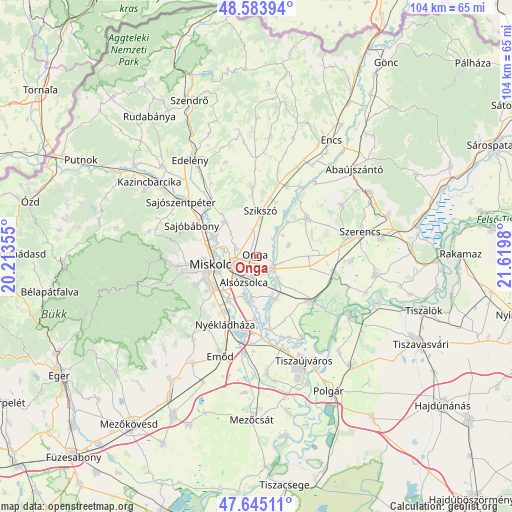
Onga GPS coordinates[2]
48° 7' 0.012" North, 20° 55' 0.012" East
| Map corner | latitude | longitude |
|---|---|---|
| Upper-left | 48.58394°, | 20.21355° |
| Center: | 48.11667°, | 20.91667° |
| Lower-right: | 47.64511°, | 21.6198° |
| Map W x H: | 104.4×104.4 km | = 64.9×64.9mi |
| max Lat: | 48.46667° ⇑7.8% North |
| Onga: | 48.11667° |
| min Lat: | ⇓92.2% South 45.79108° |
| min Long | Onga | max Long |
| 16.27358° | 20.91667° | 22.68096° |
| W 78.7%⇐ | ⇒21.3% E |
Elevation
Elevation of Onga is 113 m = 371 ft, and this is 16.7 m = 55 ft below average elevation for this country.
| Max E: |
444 m = 1457 ft | 54.7% |
| Avg. | 129.7 m = 426 ft | |
| Onga | 113 m = 371 ft | |
Min E: |
71 m = 233 ft | 45.3% |
See also: Hungary elevation on elevation.city.
Geographical zone
Onga is located in North temperate zone (between Tropic of Cancer and the Arctic Circle). Distance of this North polar circle is 2051.1 km =1274.5 mi to North.| Distance of | km | miles | from Onga |
|---|---|---|---|
| North Pole | 4657 | 2893.7 | to North |
| Arctic Circle | 2051.1 | 1274.5 | to North |
| Tropic Cancer | 2744.2 | 1705.2 | to South |
| Equator | 5350.1 | 3324.4 | to South |


Nearby cities:
15 places around Onga: (largest is in red/bold)
• Alsózsolca
5.9 km =3.7 mi,  207°
207°
• Arnót
4.6 km =2.9 mi,  289°
289°
• Aszaló
11.7 km =7.3 mi,  18°
18°
• Bőcs
8.3 km =5.2 mi,  153°
153°
• Felsőzsolca
4.1 km =2.5 mi,  243°
243°
• Gesztely
4.1 km =2.5 mi,  116°
116°
• Hernádnémeti
7.4 km =4.6 mi,  138°
138°
• Megyaszó
12.4 km =7.7 mi,  53°
53°
• Miskolc
10.1 km =6.3 mi,  259°
259°
• Mályi
12.7 km =7.9 mi, 209°
• Sajólád
7.5 km =4.7 mi,  189°
189°
• Sajóvámos
9.6 km =6 mi,  318°
318°
• Szikszó
9.3 km =5.8 mi,  7°
7°
• Szirmabesenyő
9.4 km =5.8 mi, 293°
• Ónod
13 km =8.1 mi,  180°
180°
Sources, notices
• [Note1] Compared only with cities in Hungary existing in our database
• [Src1] Map data: © OpenStreetMap contributors (CC-BY-SA)
• [Src2] Other city data from geonames.org with taken over terms of usage.
• [Src3] Geographical zone / Annual Mean Temperature by Robert A. Rohde @ Wikipedia
