Hajdúszovát geodata
Hajdúszovát (Hajdú-Bihar) is a populated place; located in Hungary in Europe/Budapest (GMT+2) time zone. With population of 3,167 people, there are 465 cities with bigger population in this country. Compared to other cities in Hungary, 52.5% of cities are located further ↑North; 87.9% of cities are located further ←West and 87.7% of cities have higher elevation than Hajdúszovát. Note1


Hajdúszovát GPS coordinates[2]
47° 22' 59.988" North, 21° 28' 59.988" East
| Map corner | latitude | longitude |
|---|---|---|
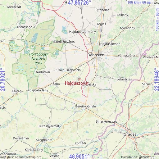
| Upper-left | 47.85726°, | 20.78021° |
| Center: | 47.38333°, | 21.48333° |
| Lower-right: | 46.9051°, | 22.18646° |
| Map W x H: | 105.9×105.9 km | = 65.8×65.8mi |
| max Lat: | 48.46667° ⇑52.5% North |
| Hajdúszovát: | 47.38333° |
| min Lat: | ⇓47.5% South 45.79108° |
| min Long | Hajdúszovát | max Long |
| 16.27358° | 21.48333° | 22.68096° |
| W 87.9%⇐ | ⇒12.1% E |
Elevation
Elevation of Hajdúszovát is 88 m = 289 ft, and this is 41.7 m = 137 ft below average elevation for this country.
| Max E: |
444 m = 1457 ft | 87.7% |
| Avg. | 129.7 m = 426 ft | |
| Hajdúszovát | 88 m = 289 ft | |
Min E: |
71 m = 233 ft | 12.3% |
See also: Hungary elevation on elevation.city.
Geographical zone
Hajdúszovát is located in North temperate zone (between Tropic of Cancer and the Arctic Circle). Distance of this North polar circle is 2132.6 km =1325.1 mi to North.| Distance of | km | miles | from Hajdúszovát |
|---|---|---|---|
| North Pole | 4738.5 | 2944.4 | to North |
| Arctic Circle | 2132.6 | 1325.1 | to North |
| Tropic Cancer | 2662.6 | 1654.5 | to South |
| Equator | 5268.5 | 3273.7 | to South |


Nearby cities:
15 places around Hajdúszovát: (largest is in red/bold)
• Berettyóújfalu
19.2 km =11.9 mi,  164°
164°
• Báránd
21 km =13 mi,  243°
243°
• Debrecen
20.1 km =12.5 mi,  34°
34°
• Derecske
7.3 km =4.5 mi,  120°
120°
• Ebes
9.4 km =5.8 mi,  7°
7°
• Földes
12.8 km =8 mi,  223°
223°
• Hajdúbagos
13.8 km =8.6 mi,  85°
85°
• Hajdúszoboszló
9.7 km =6 mi,  319°
319°
• Hosszúpályi
18.8 km =11.7 mi, 86°
• Kaba
15.5 km =9.6 mi,  256°
256°
• Konyár
15.7 km =9.8 mi, 118°
• Mikepércs
13.5 km =8.4 mi,  56°
56°
• Monostorpályi
22.7 km =14.1 mi, 85°
• Nagyrábé
23.3 km =14.5 mi,  209°
209°
• Sáránd
11.4 km =7.1 mi,  80°
80°
Sources, notices
• [Note1] Compared only with cities in Hungary existing in our database
• [Src1] Map data: © OpenStreetMap contributors (CC-BY-SA)
• [Src2] Other city data from geonames.org with taken over terms of usage.
• [Src3] Geographical zone / Annual Mean Temperature by Robert A. Rohde @ Wikipedia
