Hosszúpályi geodata
Hosszúpályi (Hajdú-Bihar) is a populated place; located in Hungary in Europe/Budapest (GMT+2) time zone. With population of 5,479 people, there are 277 cities with bigger population in this country. Compared to other cities in Hungary, 51.1% of cities are located further ↑North; 91.1% of cities are located further ←West and 63.9% of cities have higher elevation than Hosszúpályi. Note1


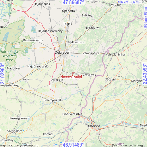
Hosszúpályi GPS coordinates[2]
47° 23' 34.908" North, 21° 43' 58.08" East
| Map corner | latitude | longitude |
|---|---|---|
| Upper-left | 47.86687°, | 21.02968° |
| Center: | 47.39303°, | 21.7328° |
| Lower-right: | 46.91489°, | 22.43593° |
| Map W x H: | 105.9×105.8 km | = 65.8×65.7mi |
| max Lat: | 48.46667° ⇑51.1% North |
| Hosszúpályi: | 47.39303° |
| min Lat: | ⇓48.9% South 45.79108° |
| min Long | Hosszúpályi | max Long |
| 16.27358° | 21.7328° | 22.68096° |
| W 91.1%⇐ | ⇒8.9% E |
Elevation
Elevation of Hosszúpályi is 107 m = 351 ft, and this is 22.7 m = 74 ft below average elevation for this country.
| Max E: |
444 m = 1457 ft | 63.9% |
| Avg. | 129.7 m = 426 ft | |
| Hosszúpályi | 107 m = 351 ft | |
Min E: |
71 m = 233 ft | 36.1% |
See also: Hungary elevation on elevation.city.
Geographical zone
Hosszúpályi is located in North temperate zone (between Tropic of Cancer and the Arctic Circle). Distance of this North polar circle is 2131.6 km =1324.5 mi to North.| Distance of | km | miles | from Hosszúpályi |
|---|---|---|---|
| North Pole | 4737.5 | 2943.7 | to North |
| Arctic Circle | 2131.6 | 1324.5 | to North |
| Tropic Cancer | 2663.7 | 1655.1 | to South |
| Equator | 5269.6 | 3274.4 | to South |


Nearby cities:
15 places around Hosszúpályi: (largest is in red/bold)
• Bagamér
20.2 km =12.6 mi,  72°
72°
• Berettyóújfalu
24 km =14.9 mi,  215°
215°
• Debrecen
17.3 km =10.7 mi,  334°
334°
• Derecske
13.4 km =8.3 mi,  249°
249°
• Ebes
19.3 km =12 mi,  295°
295°
• Hajdúbagos
5.1 km =3.2 mi,  269°
269°
• Hajdúszovát
18.8 km =11.7 mi, 266°
• Hajdúsámson
23.2 km =14.4 mi,  6°
6°
• Konyár
9.8 km =6.1 mi,  210°
210°
• Létavértes
12.6 km =7.8 mi,  94°
94°
• Mikepércs
9.8 km =6.1 mi,  310°
310°
• Monostorpályi
3.9 km =2.4 mi,  78°
78°
• Pocsaj
13.7 km =8.5 mi,  152°
152°
• Sáránd
7.5 km =4.7 mi,  275°
275°
• Vámospércs
20 km =12.4 mi,  38°
38°
Sources, notices
• [Note1] Compared only with cities in Hungary existing in our database
• [Src1] Map data: © OpenStreetMap contributors (CC-BY-SA)
• [Src2] Other city data from geonames.org with taken over terms of usage.
• [Src3] Geographical zone / Annual Mean Temperature by Robert A. Rohde @ Wikipedia
