Ploso geodata
Ploso (East Java) is a seat of a fourth-order administrative division; located in Indonesia in Asia/Jakarta (GMT+7) time zone. In our database, there are 407 cities with bigger population. Compared to other cities in Indonesia, 53.1% of cities are located further ↓South; 57.5% of cities are located further ←West and 98.5% of cities have higher elevation than Ploso. Note1


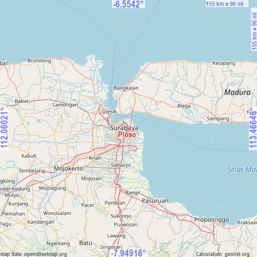
Ploso GPS coordinates[2]
7° 15' 7.992" South, 112° 45' 47.988" East
| Map corner | latitude | longitude |
|---|---|---|
| Upper-left | -6.5542°, | 112.06021° |
| Center: | -7.25222°, | 112.76333° |
| Lower-right: | -7.94916°, | 113.46646° |
| Map W x H: | 155.1×155.1 km | = 96.4×96.4mi |
| max Lat: | 5.88969° ⇑46.9% North |
| Ploso: | -7.25222° |
| min Lat: | ⇓53.1% South -10.934° |
| min Long | Ploso | max Long |
| 95.1345° | 112.76333° | 140.9419° |
| W 57.5%⇐ | ⇒42.5% E |
Elevation
Elevation of Ploso is 5 m = 16 ft, and this is 224.7 m = 737 ft below average elevation for this country.
| Max E: |
3185 m = 10449 ft | 98.5% |
| Avg. | 229.7 m = 754 ft | |
| Ploso | 5 m = 16 ft | |
Min E: |
-1 m = -3 ft | 1.5% |
See also: Indonesia elevation on elevation.city.
Geographical zone
Ploso is located in South Torrid zone (between Equator and Tropic of Capricorn). Distance of Equator is 806.4 km =501.1 mi to North.| Distance of | km | miles | from Ploso |
|---|---|---|---|
| Equator | 806.4 | 501.1 | to North |
| Tropic Capricorn | 1799.5 | 1118.2 | to South |
| Antarctic Circle | 6594.8 | 4097.8 | to South |
| South Pole | 9200.7 | 5717 | to South |


Nearby cities:
15 places around Ploso: (largest is in red/bold)
• Brongkalan
0.7 km =0.4 mi,  142°
142°
• Gubengairlangga
2.4 km =1.5 mi,  196°
196°
• Gununganyar
10.1 km =6.3 mi,  168°
168°
• Jagirsidosermo
6.1 km =3.8 mi,  189°
189°
• Kedungasem
7.9 km =4.9 mi, 167°
• Labansari
3.2 km =2 mi,  105°
105°
• Medokanayu
9 km =5.6 mi,  154°
154°
• Mulyorejo
2.6 km =1.6 mi,  117°
117°
• Pacarkeling
0.9 km =0.6 mi,  221°
221°
• Panjangjiwo
6.7 km =4.2 mi,  179°
179°
• Prapen
7 km =4.3 mi, 186°
• Semampir
6.5 km =4 mi,  163°
163°
• Surabaya
1.4 km =0.9 mi,  283°
283°
• Tenggilis Lama
7.2 km =4.5 mi, 180°
• Wonorejo
7.5 km =4.7 mi, 150°
Sources, notices
• [Note1] Compared only with cities in Indonesia existing in our database
• [Src1] Map data: © OpenStreetMap contributors (CC-BY-SA)
• [Src2] Other city data from geonames.org with taken over terms of usage.
• [Src3] Geographical zone / Annual Mean Temperature by Robert A. Rohde @ Wikipedia
