Gununganyar geodata
Gununganyar (East Java) is a seat of a third-order administrative division; located in Indonesia in Asia/Jakarta (GMT+7) time zone. In our database, there are 407 cities with bigger population. Compared to other cities in Indonesia, 50.8% of cities are located further ↑North; 57.8% of cities are located further ←West and 99.1% of cities have higher elevation than Gununganyar. Note1


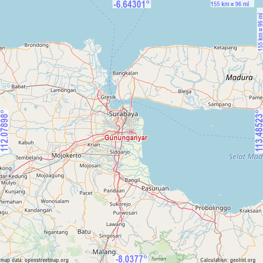
Gununganyar GPS coordinates[2]
7° 20' 27.24" South, 112° 46' 55.56" East
| Map corner | latitude | longitude |
|---|---|---|
| Upper-left | -6.64301°, | 112.07898° |
| Center: | -7.3409°, | 112.7821° |
| Lower-right: | -8.0377°, | 113.48523° |
| Map W x H: | 155.1×155.1 km | = 96.4×96.4mi |
| max Lat: | 5.88969° ⇑50.8% North |
| Gununganyar: | -7.3409° |
| min Lat: | ⇓49.2% South -10.934° |
| min Long | Gununganyar | max Long |
| 95.1345° | 112.7821° | 140.9419° |
| W 57.8%⇐ | ⇒42.2% E |
Elevation
Elevation of Gununganyar is 4 m = 13 ft, and this is 225.7 m = 740 ft below average elevation for this country.
| Max E: |
3185 m = 10449 ft | 99.1% |
| Avg. | 229.7 m = 754 ft | |
| Gununganyar | 4 m = 13 ft | |
Min E: |
-1 m = -3 ft | 0.9% |
See also: Indonesia elevation on elevation.city.
Geographical zone
Gununganyar is located in South Torrid zone (between Equator and Tropic of Capricorn). Distance of Equator is 816.2 km =507.2 mi to North.| Distance of | km | miles | from Gununganyar |
|---|---|---|---|
| Equator | 816.2 | 507.2 | to North |
| Tropic Capricorn | 1789.7 | 1112.1 | to South |
| Antarctic Circle | 6584.9 | 4091.7 | to South |
| South Pole | 9190.8 | 5710.9 | to South |


Nearby cities:
15 places around Gununganyar: (largest is in red/bold)
• Berbek
2.1 km =1.3 mi,  253°
253°
• Dares
3.8 km =2.4 mi,  214°
214°
• Gununganyartambak Tengah
2.2 km =1.4 mi,  80°
80°
• Kedungasem
2.2 km =1.4 mi,  350°
350°
• Medokanayu
2.5 km =1.6 mi,  47°
47°
• Panjangjiwo
3.7 km =2.3 mi,  327°
327°
• Segorotambak
4 km =2.5 mi,  135°
135°
• Semampir
3.6 km =2.2 mi,  356°
356°
• Semampirbarat
3.6 km =2.2 mi,  196°
196°
• Tambakoso
2.5 km =1.6 mi,  103°
103°
• Tambaksumur
1.3 km =0.8 mi,  230°
230°
• Tenggilis Lama
3.4 km =2.1 mi,  321°
321°
• Wadungasri
1.6 km =1 mi, 252°
• Wedoro
3.6 km =2.2 mi, 251°
• Wonorejo
3.7 km =2.3 mi,  26°
26°
Sources, notices
• [Note1] Compared only with cities in Indonesia existing in our database
• [Src1] Map data: © OpenStreetMap contributors (CC-BY-SA)
• [Src2] Other city data from geonames.org with taken over terms of usage.
• [Src3] Geographical zone / Annual Mean Temperature by Robert A. Rohde @ Wikipedia
