Sawahan geodata
Sawahan (East Java) is a seat of a fourth-order administrative division; located in Indonesia in Asia/Jakarta (GMT+7) time zone. In our database, there are 407 cities with bigger population. Compared to other cities in Indonesia, 72.3% of cities are located further ↑North; 56.6% of cities are located further ←West and 74.6% of cities have lower elevation than Sawahan. Note1


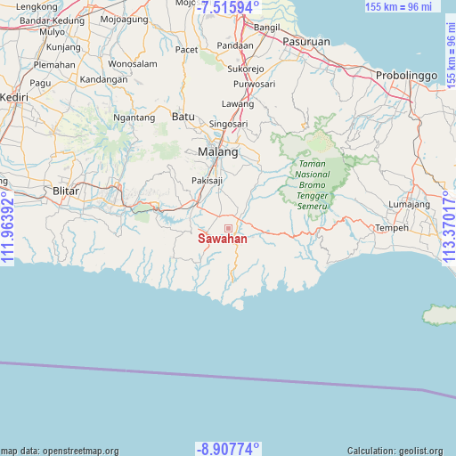
Sawahan GPS coordinates[2]
8° 12' 44.82" South, 112° 40' 1.344" East
| Map corner | latitude | longitude |
|---|---|---|
| Upper-left | -7.51594°, | 111.96392° |
| Center: | -8.21245°, | 112.66704° |
| Lower-right: | -8.90774°, | 113.37017° |
| Map W x H: | 154.8×154.8 km | = 96.2×96.2mi |
| max Lat: | 5.88969° ⇑72.3% North |
| Sawahan: | -8.21245° |
| min Lat: | ⇓27.7% South -10.934° |
| min Long | Sawahan | max Long |
| 95.1345° | 112.66704° | 140.9419° |
| W 56.6%⇐ | ⇒43.4% E |
Elevation
Elevation of Sawahan is 353 m = 1158 ft, and this is 123.3 m = 405 ft above average elevation for this country.
| Max E: |
3185 m = 10449 ft | 25.4% |
| Sawahan | 353 m 1158 ft | |
| Avg. | 229.7 m = 754 ft | |
Min E: |
-1 m = -3 ft | 74.6% |
See also: Indonesia elevation on elevation.city.
Geographical zone
Sawahan is located in South Torrid zone (between Equator and Tropic of Capricorn). Distance of Equator is 913.1 km =567.4 mi to North.| Distance of | km | miles | from Sawahan |
|---|---|---|---|
| Equator | 913.1 | 567.4 | to North |
| Tropic Capricorn | 1692.8 | 1051.9 | to South |
| Antarctic Circle | 6488 | 4031.5 | to South |
| South Pole | 9093.9 | 5650.7 | to South |


Nearby cities:
15 places around Sawahan: (largest is in red/bold)
• Adirejo
3.1 km =1.9 mi,  270°
270°
• Gedog Wetan
3.4 km =2.1 mi,  65°
65°
• Gondanglegi Wetan
4.7 km =2.9 mi,  321°
321°
• Kemulan
1.5 km =0.9 mi,  225°
225°
• Pagelaran
5.4 km =3.4 mi,  287°
287°
• Putat Kidul
4.9 km =3 mi,  329°
329°
• Rembun
5.4 km =3.4 mi, 67°
• Sedayu
4.3 km =2.7 mi,  31°
31°
• Segaran
5.2 km =3.2 mi, 230°
• Sepanjang
4.7 km =2.9 mi,  354°
354°
• Talok
4.7 km =2.9 mi,  52°
52°
• Tanggung
4.7 km =2.9 mi,  14°
14°
• Tawangrejeni
2.5 km =1.6 mi,  116°
116°
• Turen
4.9 km =3 mi, 25°
• Undaan
2.2 km =1.4 mi, 32°
Sources, notices
• [Note1] Compared only with cities in Indonesia existing in our database
• [Src1] Map data: © OpenStreetMap contributors (CC-BY-SA)
• [Src2] Other city data from geonames.org with taken over terms of usage.
• [Src3] Geographical zone / Annual Mean Temperature by Robert A. Rohde @ Wikipedia
