Rembun geodata
Rembun (East Java) is a seat of a fourth-order administrative division; located in Indonesia in Asia/Jakarta (GMT+7) time zone. In our database, there are 407 cities with bigger population. Compared to other cities in Indonesia, 71.2% of cities are located further ↑North; 57% of cities are located further ←West and 76.9% of cities have lower elevation than Rembun. Note1


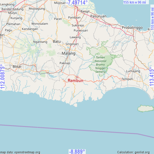
Rembun GPS coordinates[2]
8° 11' 37.248" South, 112° 42' 42.732" East
| Map corner | latitude | longitude |
|---|---|---|
| Upper-left | -7.49714°, | 112.00875° |
| Center: | -8.19368°, | 112.71187° |
| Lower-right: | -8.889°, | 113.415° |
| Map W x H: | 154.8×154.8 km | = 96.2×96.2mi |
| max Lat: | 5.88969° ⇑71.2% North |
| Rembun: | -8.19368° |
| min Lat: | ⇓28.8% South -10.934° |
| min Long | Rembun | max Long |
| 95.1345° | 112.71187° | 140.9419° |
| W 57%⇐ | ⇒43% E |
Elevation
Elevation of Rembun is 383 m = 1257 ft, and this is 153.3 m = 503 ft above average elevation for this country.
| Max E: |
3185 m = 10449 ft | 23.1% |
| Rembun | 383 m 1257 ft | |
| Avg. | 229.7 m = 754 ft | |
Min E: |
-1 m = -3 ft | 76.9% |
See also: Indonesia elevation on elevation.city.
Geographical zone
Rembun is located in South Torrid zone (between Equator and Tropic of Capricorn). Distance of Equator is 911.1 km =566.1 mi to North.| Distance of | km | miles | from Rembun |
|---|---|---|---|
| Equator | 911.1 | 566.1 | to North |
| Tropic Capricorn | 1694.9 | 1053.2 | to South |
| Antarctic Circle | 6490.1 | 4032.8 | to South |
| South Pole | 9096 | 5652 | to South |


Nearby cities:
15 places around Rembun: (largest is in red/bold)
• Dampit
4.6 km =2.9 mi,  115°
115°
• Gedog Wetan
1.9 km =1.2 mi,  250°
250°
• Jambangan
4.5 km =2.8 mi,  39°
39°
• Kedok
5.3 km =3.3 mi,  339°
339°
• Majang Tengah
1 km =0.6 mi,  111°
111°
• Pagedangan
3.8 km =2.4 mi,  5°
5°
• Pamotan
2.6 km =1.6 mi,  104°
104°
• Pojok
2.1 km =1.3 mi,  28°
28°
• Sananrejo
5 km =3.1 mi, 7°
• Sedayu
3.1 km =1.9 mi,  300°
300°
• Talok
1.4 km =0.9 mi, 303°
• Tanggung
4.5 km =2.8 mi, 303°
• Tawangrejeni
4.2 km =2.6 mi,  219°
219°
• Turen
3.7 km =2.3 mi,  309°
309°
• Undaan
3.8 km =2.4 mi,  266°
266°
Sources, notices
• [Note1] Compared only with cities in Indonesia existing in our database
• [Src1] Map data: © OpenStreetMap contributors (CC-BY-SA)
• [Src2] Other city data from geonames.org with taken over terms of usage.
• [Src3] Geographical zone / Annual Mean Temperature by Robert A. Rohde @ Wikipedia
