Dampit geodata
Dampit (East Java) is a seat of a third-order administrative division; located in Indonesia in Asia/Jakarta (GMT+7) time zone. With population of 23,094 people, there are 363 cities with bigger population in this country. Compared to other cities in Indonesia, 72.2% of cities are located further ↑North; 57.3% of cities are located further ←West and 79.9% of cities have lower elevation than Dampit. Note1


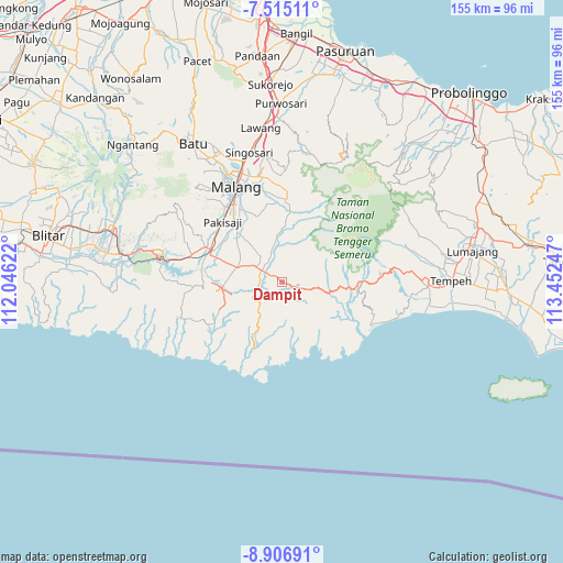
Dampit GPS coordinates[2]
8° 12' 41.832" South, 112° 44' 57.624" East
| Map corner | latitude | longitude |
|---|---|---|
| Upper-left | -7.51511°, | 112.04622° |
| Center: | -8.21162°, | 112.74934° |
| Lower-right: | -8.90691°, | 113.45247° |
| Map W x H: | 154.8×154.8 km | = 96.2×96.2mi |
| max Lat: | 5.88969° ⇑72.2% North |
| Dampit: | -8.21162° |
| min Lat: | ⇓27.8% South -10.934° |
| min Long | Dampit | max Long |
| 95.1345° | 112.74934° | 140.9419° |
| W 57.3%⇐ | ⇒42.7% E |
Elevation
Elevation of Dampit is 430 m = 1411 ft, and this is 200.3 m = 657 ft above average elevation for this country.
| Max E: |
3185 m = 10449 ft | 20.1% |
| Dampit | 430 m 1411 ft | |
| Avg. | 229.7 m = 754 ft | |
Min E: |
-1 m = -3 ft | 79.9% |
See also: Indonesia elevation on elevation.city.
Geographical zone
Dampit is located in South Torrid zone (between Equator and Tropic of Capricorn). Distance of Equator is 913 km =567.3 mi to North.| Distance of | km | miles | from Dampit |
|---|---|---|---|
| Equator | 913 | 567.3 | to North |
| Tropic Capricorn | 1692.9 | 1051.9 | to South |
| Antarctic Circle | 6488.1 | 4031.5 | to South |
| South Pole | 9094 | 5650.7 | to South |


Nearby cities:
15 places around Dampit: (largest is in red/bold)
• Donorejo
7.7 km =4.8 mi,  185°
185°
• Gedog Wetan
6.1 km =3.8 mi,  282°
282°
• Jambangan
5.6 km =3.5 mi,  347°
347°
• Klepu Krajan
6 km =3.7 mi,  197°
197°
• Krajan Harjokuncaran
7.7 km =4.8 mi,  220°
220°
• Majang Tengah
3.6 km =2.2 mi,  297°
297°
• Pagedangan
6.9 km =4.3 mi,  327°
327°
• Pamotan
2.1 km =1.3 mi,  310°
310°
• Pojok
4.9 km =3 mi,  320°
320°
• Rembun
4.6 km =2.9 mi, 295°
• Sanankerto
6.8 km =4.2 mi,  356°
356°
• Sekarbanyu
5.8 km =3.6 mi,  176°
176°
• Sumberarum
6.9 km =4.3 mi,  153°
153°
• Talok
6 km =3.7 mi, 297°
• Tawangrejeni
6.9 km =4.3 mi,  259°
259°
Sources, notices
• [Note1] Compared only with cities in Indonesia existing in our database
• [Src1] Map data: © OpenStreetMap contributors (CC-BY-SA)
• [Src2] Other city data from geonames.org with taken over terms of usage.
• [Src3] Geographical zone / Annual Mean Temperature by Robert A. Rohde @ Wikipedia
