Oebelo geodata
Oebelo (East Nusa Tenggara) is a seat of a fourth-order administrative division; located in Indonesia in Asia/Makassar (GMT+8) time zone. In our database, there are 407 cities with bigger population. Compared to other cities in Indonesia, 97.4% of cities are located further ↑North; 93.6% of cities are located further ←West and 78.1% of cities have higher elevation than Oebelo. Note1


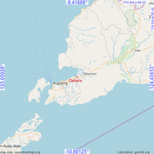
Oebelo GPS coordinates[2]
10° 6' 35.28" South, 123° 45' 12.24" East
| Map corner | latitude | longitude |
|---|---|---|
| Upper-left | -9.41686°, | 123.05028° |
| Center: | -10.1098°, | 123.7534° |
| Lower-right: | -10.80125°, | 124.45653° |
| Map W x H: | 153.9×153.9 km | = 95.6×95.6mi |
| max Lat: | 5.88969° ⇑97.4% North |
| Oebelo: | -10.1098° |
| min Lat: | ⇓2.6% South -10.934° |
| min Long | Oebelo | max Long |
| 95.1345° | 123.7534° | 140.9419° |
| W 93.6%⇐ | ⇒6.4% E |
Elevation
Elevation of Oebelo is 21 m = 69 ft, and this is 208.7 m = 685 ft below average elevation for this country.
| Max E: |
3185 m = 10449 ft | 78.1% |
| Avg. | 229.7 m = 754 ft | |
| Oebelo | 21 m = 69 ft | |
Min E: |
-1 m = -3 ft | 21.9% |
See also: Indonesia elevation on elevation.city.
Geographical zone
Oebelo is located in South Torrid zone (between Equator and Tropic of Capricorn). Distance of Equator is 1124.1 km =698.5 mi to North.| Distance of | km | miles | from Oebelo |
|---|---|---|---|
| Equator | 1124.1 | 698.5 | to North |
| Tropic Capricorn | 1481.8 | 920.7 | to South |
| Antarctic Circle | 6277.1 | 3900.4 | to South |
| South Pole | 8883 | 5519.6 | to South |


Nearby cities:
15 places around Oebelo: (largest is in red/bold)
• Babau
3.6 km =2.2 mi,  82°
82°
• Banupo
4.7 km =2.9 mi,  144°
144°
• Bijaenaka
4.3 km =2.7 mi,  190°
190°
• Kiuteta
5 km =3.1 mi,  246°
246°
• Lasiana
9.7 km =6 mi, 251°
• Mekon
9.3 km =5.8 mi,  230°
230°
• Merdeka
2.9 km =1.8 mi, 83°
• Naibonat
7.9 km =4.9 mi, 84°
• Nunkurus
9.5 km =5.9 mi,  57°
57°
• Oesao
6.5 km =4 mi,  100°
100°
• Pukdale
8.7 km =5.4 mi, 97°
• Taklale
5 km =3.1 mi,  86°
86°
• Tarus
7.6 km =4.7 mi, 250°
• Tuapukan
2.3 km =1.4 mi, 86°
• Tuatuka
10.3 km =6.4 mi,  119°
119°
Sources, notices
• [Note1] Compared only with cities in Indonesia existing in our database
• [Src1] Map data: © OpenStreetMap contributors (CC-BY-SA)
• [Src2] Other city data from geonames.org with taken over terms of usage.
• [Src3] Geographical zone / Annual Mean Temperature by Robert A. Rohde @ Wikipedia
