Oesao geodata
Oesao (East Nusa Tenggara) is a seat of a fourth-order administrative division; located in Indonesia in Asia/Makassar (GMT+8) time zone. In our database, there are 407 cities with bigger population. Compared to other cities in Indonesia, 97.4% of cities are located further ↑North; 93.9% of cities are located further ←West and 66.8% of cities have higher elevation than Oesao. Note1


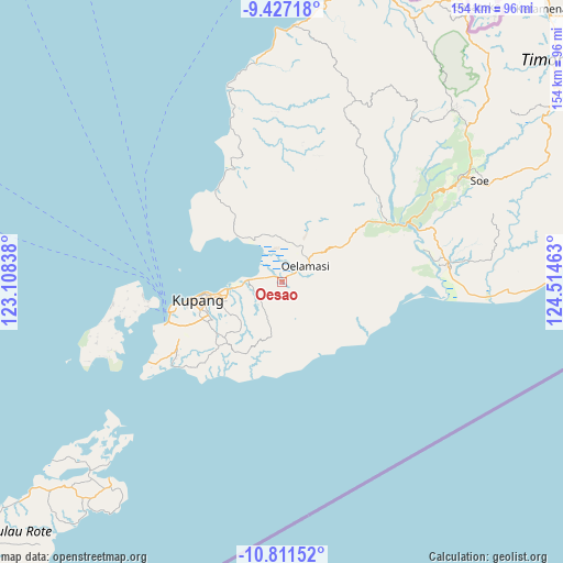
Oesao GPS coordinates[2]
10° 7' 12.36" South, 123° 48' 41.4" East
| Map corner | latitude | longitude |
|---|---|---|
| Upper-left | -9.42718°, | 123.10838° |
| Center: | -10.1201°, | 123.8115° |
| Lower-right: | -10.81152°, | 124.51463° |
| Map W x H: | 153.9×153.9 km | = 95.6×95.6mi |
| max Lat: | 5.88969° ⇑97.4% North |
| Oesao: | -10.1201° |
| min Lat: | ⇓2.6% South -10.934° |
| min Long | Oesao | max Long |
| 95.1345° | 123.8115° | 140.9419° |
| W 93.9%⇐ | ⇒6.1% E |
Elevation
Elevation of Oesao is 38 m = 125 ft, and this is 191.7 m = 629 ft below average elevation for this country.
| Max E: |
3185 m = 10449 ft | 66.8% |
| Avg. | 229.7 m = 754 ft | |
| Oesao | 38 m = 125 ft | |
Min E: |
-1 m = -3 ft | 33.2% |
See also: Indonesia elevation on elevation.city.
Geographical zone
Oesao is located in South Torrid zone (between Equator and Tropic of Capricorn). Distance of Equator is 1125.2 km =699.2 mi to North.| Distance of | km | miles | from Oesao |
|---|---|---|---|
| Equator | 1125.2 | 699.2 | to North |
| Tropic Capricorn | 1480.7 | 920.1 | to South |
| Antarctic Circle | 6275.9 | 3899.7 | to South |
| South Pole | 8881.8 | 5518.9 | to South |


Nearby cities:
15 places around Oesao: (largest is in red/bold)
• Babau
3.2 km =2 mi,  300°
300°
• Banupo
4.5 km =2.8 mi,  232°
232°
• Bijaenaka
7.8 km =4.8 mi,  246°
246°
• Kiukasen
10.4 km =6.5 mi,  97°
97°
• Kuanheum
9 km =5.6 mi,  131°
131°
• Merdeka
3.8 km =2.4 mi,  292°
292°
• Naibonat
2.4 km =1.5 mi,  39°
39°
• Nis’oni
4.4 km =2.7 mi,  120°
120°
• Nunkurus
6.5 km =4 mi,  14°
14°
• Oebelo
6.5 km =4 mi,  280°
280°
• Oelamasi
9.6 km =6 mi,  49°
49°
• Pukdale
2.2 km =1.4 mi,  90°
90°
• Taklale
1.9 km =1.2 mi,  317°
317°
• Tuapukan
4.3 km =2.7 mi, 287°
• Tuatuka
4.7 km =2.9 mi,  145°
145°
Sources, notices
• [Note1] Compared only with cities in Indonesia existing in our database
• [Src1] Map data: © OpenStreetMap contributors (CC-BY-SA)
• [Src2] Other city data from geonames.org with taken over terms of usage.
• [Src3] Geographical zone / Annual Mean Temperature by Robert A. Rohde @ Wikipedia
