Lailunggi geodata
Lailunggi (East Nusa Tenggara) is a seat of a fourth-order administrative division; located in Indonesia in Asia/Makassar (GMT+8) time zone. In our database, there are 407 cities with bigger population. Compared to other cities in Indonesia, 97.8% of cities are located further ↑North; 83.1% of cities are located further ←West and 80.9% of cities have higher elevation than Lailunggi. Note1


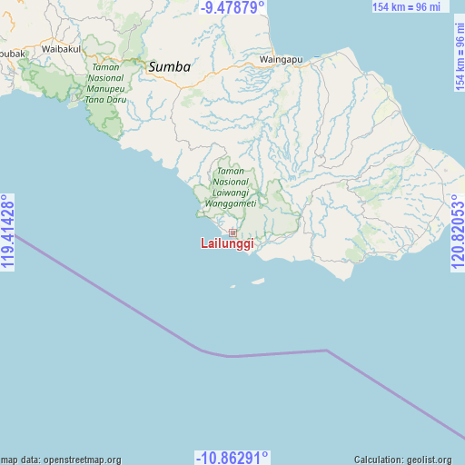
Lailunggi GPS coordinates[2]
10° 10' 17.76" South, 120° 7' 2.64" East
| Map corner | latitude | longitude |
|---|---|---|
| Upper-left | -9.47879°, | 119.41428° |
| Center: | -10.1716°, | 120.1174° |
| Lower-right: | -10.86291°, | 120.82053° |
| Map W x H: | 153.9×153.9 km | = 95.6×95.6mi |
| max Lat: | 5.88969° ⇑97.8% North |
| Lailunggi: | -10.1716° |
| min Lat: | ⇓2.2% South -10.934° |
| min Long | Lailunggi | max Long |
| 95.1345° | 120.1174° | 140.9419° |
| W 83.1%⇐ | ⇒16.9% E |
Elevation
Elevation of Lailunggi is 18 m = 59 ft, and this is 211.7 m = 695 ft below average elevation for this country.
| Max E: |
3185 m = 10449 ft | 80.9% |
| Avg. | 229.7 m = 754 ft | |
| Lailunggi | 18 m = 59 ft | |
Min E: |
-1 m = -3 ft | 19.1% |
See also: Indonesia elevation on elevation.city.
Geographical zone
Lailunggi is located in South Torrid zone (between Equator and Tropic of Capricorn). Distance of Equator is 1131 km =702.8 mi to North.| Distance of | km | miles | from Lailunggi |
|---|---|---|---|
| Equator | 1131 | 702.8 | to North |
| Tropic Capricorn | 1474.9 | 916.5 | to South |
| Antarctic Circle | 6270.2 | 3896.1 | to South |
| South Pole | 8876.1 | 5515.4 | to South |


Nearby cities:
15 places around Lailunggi: (largest is in red/bold)
• Billa
25.4 km =15.8 mi,  350°
350°
• Kalangga
21.5 km =13.4 mi,  86°
86°
• Karita
26.9 km =16.7 mi,  356°
356°
• Laironja
20.3 km =12.6 mi,  59°
59°
• Malahar
25.2 km =15.7 mi, 348°
• Maradabangga
26.5 km =16.5 mi, 91°
• Nggai
26.1 km =16.2 mi,  98°
98°
• Nggongi
13 km =8.1 mi, 101°
• Nggongi Satu
12.7 km =7.9 mi, 101°
• Praingkareha
19.3 km =12 mi,  335°
335°
• Tanarara Timur
26.4 km =16.4 mi,  47°
47°
• Tatunggu
24.4 km =15.2 mi,  71°
71°
• Tawui
5.8 km =3.6 mi,  303°
303°
• Wahang Dua
13 km =8.1 mi,  311°
311°
• Walakeri
26.4 km =16.4 mi,  8°
8°
Sources, notices
• [Note1] Compared only with cities in Indonesia existing in our database
• [Src1] Map data: © OpenStreetMap contributors (CC-BY-SA)
• [Src2] Other city data from geonames.org with taken over terms of usage.
• [Src3] Geographical zone / Annual Mean Temperature by Robert A. Rohde @ Wikipedia
