Kupang geodata
Kupang (East Nusa Tenggara) is a seat of a first-order administrative division; located in Indonesia in Asia/Makassar (GMT+8) time zone. With population of 282,396 people, there are 35 cities with bigger population in this country. Compared to other cities in Indonesia, 97.8% of cities are located further ↑North; 93% of cities are located further ←West and 52.3% of cities have higher elevation than Kupang. Note1


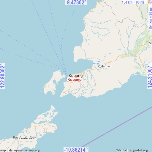
Kupang GPS coordinates[2]
10° 10' 14.988" South, 123° 36' 24.984" East
| Map corner | latitude | longitude |
|---|---|---|
| Upper-left | -9.47802°, | 122.90382° |
| Center: | -10.17083°, | 123.60694° |
| Lower-right: | -10.86214°, | 124.31007° |
| Map W x H: | 153.9×153.9 km | = 95.6×95.6mi |
| max Lat: | 5.88969° ⇑97.8% North |
| Kupang: | -10.17083° |
| min Lat: | ⇓2.2% South -10.934° |
| min Long | Kupang | max Long |
| 95.1345° | 123.60694° | 140.9419° |
| W 93%⇐ | ⇒7% E |
Elevation
Elevation of Kupang is 94 m = 308 ft, and this is 135.7 m = 445 ft below average elevation for this country.
| Max E: |
3185 m = 10449 ft | 52.3% |
| Avg. | 229.7 m = 754 ft | |
| Kupang | 94 m = 308 ft | |
Min E: |
-1 m = -3 ft | 47.7% |
See also: Kupang elevation on elevation.city.
Geographical zone
Kupang is located in South Torrid zone (between Equator and Tropic of Capricorn). Distance of Equator is 1130.9 km =702.7 mi to North.| Distance of | km | miles | from Kupang |
|---|---|---|---|
| Equator | 1130.9 | 702.7 | to North |
| Tropic Capricorn | 1475 | 916.5 | to South |
| Antarctic Circle | 6270.3 | 3896.2 | to South |
| South Pole | 8876.2 | 5515.4 | to South |


Nearby cities:
15 places around Kupang: (largest is in red/bold)
• Airnona
2.7 km =1.7 mi,  244°
244°
• Bakunase
2.8 km =1.7 mi,  233°
233°
• Fontein
2.8 km =1.7 mi,  280°
280°
• Kelapalima
2.7 km =1.7 mi,  30°
30°
• Kuanino
1.9 km =1.2 mi,  269°
269°
• Mantasi
2.9 km =1.8 mi,  264°
264°
• Maulafa
2.4 km =1.5 mi,  134°
134°
• Merdeka
2.4 km =1.5 mi,  293°
293°
• Naikoten Dua
1 km =0.6 mi, 256°
• Oeba
2.1 km =1.3 mi,  307°
307°
• Oebobo
0.9 km =0.6 mi, 291°
• Oebufu
1.8 km =1.1 mi,  119°
119°
• Oepura
2 km =1.2 mi,  177°
177°
• Oetete
2.2 km =1.4 mi, 286°
• Pasirpanjang
1.7 km =1.1 mi,  342°
342°
Sources, notices
• [Note1] Compared only with cities in Indonesia existing in our database
• [Src1] Map data: © OpenStreetMap contributors (CC-BY-SA)
• [Src2] Other city data from geonames.org with taken over terms of usage.
• [Src3] Geographical zone / Annual Mean Temperature by Robert A. Rohde @ Wikipedia
