VILLA PERMATA HIJAU geodata
VILLA PERMATA HIJAU (West Java) is a populated place; located in Indonesia in Asia/Jakarta (GMT+7) time zone. With population of 1,000 people, there are 401 cities with bigger population in this country. Compared to other cities in Indonesia, 88% of cities are located further ↓South; 89.8% of cities are located further →East and 90.6% of cities have higher elevation than VILLA PERMATA HIJAU. Note1


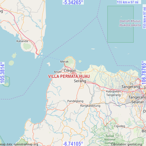
VILLA PERMATA HIJAU GPS coordinates[2]
6° 2' 32.28" South, 106° 5' 4.272" East
| Map corner | latitude | longitude |
|---|---|---|
| Upper-left | -5.34265°, | 105.3814° |
| Center: | -6.0423°, | 106.08452° |
| Lower-right: | -6.74105°, | 106.78765° |
| Map W x H: | 155.5×155.5 km | = 96.6×96.6mi |
| max Lat: | 5.88969° ⇑12% North |
| VILLA PERMATA HIJAU: | -6.0423° |
| min Lat: | ⇓88% South -10.934° |
| min Long | VILLA PERMATA H | max Long |
| 95.1345° | 106.08452° | 140.9419° |
| W 10.2%⇐ | ⇒89.8% E |
Elevation
Elevation of VILLA PERMATA HIJAU is 10 m = 33 ft, and this is 219.7 m = 721 ft below average elevation for this country.
| Max E: |
3185 m = 10449 ft | 90.6% |
| Avg. | 229.7 m = 754 ft | |
| VILLA PERMATA HIJAU | 10 m = 33 ft | |
Min E: |
-1 m = -3 ft | 9.4% |
See also: Indonesia elevation on elevation.city.
Geographical zone
VILLA PERMATA HIJAU is located in South Torrid zone (between Equator and Tropic of Capricorn). Distance of Equator is 671.8 km =417.4 mi to North.| Distance of | km | miles | from VILLA PERMATA HIJAU |
|---|---|---|---|
| Equator | 671.8 | 417.4 | to North |
| Tropic Capricorn | 1934.1 | 1201.8 | to South |
| Antarctic Circle | 6729.3 | 4181.4 | to South |
| South Pole | 9335.2 | 5800.6 | to South |


Nearby cities:
15 places around VILLA PERMATA HIJAU: (largest is in red/bold)
• Bojonegara
8.1 km =5 mi,  8°
8°
• Bojong
13.3 km =8.3 mi,  177°
177°
• Bojongseler
12.5 km =7.8 mi,  206°
206°
• Cikedung
14.8 km =9.2 mi,  227°
227°
• Curug
9.9 km =6.2 mi,  313°
313°
• Gunungsari
13.6 km =8.5 mi,  190°
190°
• Karangdawa Barat
10.4 km =6.5 mi,  163°
163°
• Merapit
12.7 km =7.9 mi, 191°
• Padukan
12.1 km =7.5 mi,  169°
169°
• Pakuncen
9.9 km =6.2 mi,  351°
351°
• Panenjoan
13.1 km =8.1 mi,  222°
222°
• Pangarengan
9.6 km =6 mi, 352°
• Pekijing
9.3 km =5.8 mi, 167°
• Serang
11.2 km =7 mi,  136°
136°
• Uluarang
12.5 km =7.8 mi,  200°
200°
Sources, notices
• [Note1] Compared only with cities in Indonesia existing in our database
• [Src1] Map data: © OpenStreetMap contributors (CC-BY-SA)
• [Src2] Other city data from geonames.org with taken over terms of usage.
• [Src3] Geographical zone / Annual Mean Temperature by Robert A. Rohde @ Wikipedia
