Mirigambar geodata
Mirigambar (East Java) is a seat of a fourth-order administrative division; located in Indonesia in Asia/Jakarta (GMT+7) time zone. In our database, there are 407 cities with bigger population. Compared to other cities in Indonesia, 67.5% of cities are located further ↑North; 50.3% of cities are located further →East and 51.9% of cities have lower elevation than Mirigambar. Note1


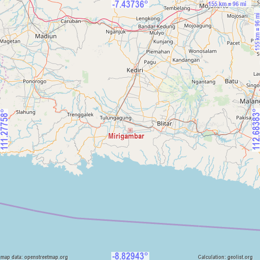
Mirigambar GPS coordinates[2]
8° 8' 2.4" South, 111° 58' 50.52" East
| Map corner | latitude | longitude |
|---|---|---|
| Upper-left | -7.43736°, | 111.27758° |
| Center: | -8.134°, | 111.9807° |
| Lower-right: | -8.82943°, | 112.68383° |
| Map W x H: | 154.8×154.8 km | = 96.2×96.2mi |
| max Lat: | 5.88969° ⇑67.5% North |
| Mirigambar: | -8.134° |
| min Lat: | ⇓32.5% South -10.934° |
| min Long | Mirigambar | max Long |
| 95.1345° | 111.9807° | 140.9419° |
| W 49.7%⇐ | ⇒50.3% E |
Elevation
Elevation of Mirigambar is 109 m = 358 ft, and this is 120.7 m = 396 ft below average elevation for this country.
| Max E: |
3185 m = 10449 ft | 48.1% |
| Avg. | 229.7 m = 754 ft | |
| Mirigambar | 109 m = 358 ft | |
Min E: |
-1 m = -3 ft | 51.9% |
See also: Indonesia elevation on elevation.city.
Geographical zone
Mirigambar is located in South Torrid zone (between Equator and Tropic of Capricorn). Distance of Equator is 904.4 km =562 mi to North.| Distance of | km | miles | from Mirigambar |
|---|---|---|---|
| Equator | 904.4 | 562 | to North |
| Tropic Capricorn | 1701.5 | 1057.3 | to South |
| Antarctic Circle | 6496.8 | 4036.9 | to South |
| South Pole | 9102.6 | 5656.1 | to South |


Nearby cities:
15 places around Mirigambar: (largest is in red/bold)
• Balesono
0.8 km =0.5 mi,  134°
134°
• Bendorubuh
2.4 km =1.5 mi,  99°
99°
• Brandil
3 km =1.9 mi,  244°
244°
• Cangkringan
1.9 km =1.2 mi,  324°
324°
• Domasan
1.3 km =0.8 mi,  203°
203°
• Dukuh
2.8 km =1.7 mi,  350°
350°
• Pandansari
0.8 km =0.5 mi,  14°
14°
• Salakan Lor
2.9 km =1.8 mi,  151°
151°
• Sambidoplang
1.6 km =1 mi,  255°
255°
• Samir
2.7 km =1.7 mi,  122°
122°
• Selorejo
1.6 km =1 mi,  107°
107°
• Sumberingin Kulon
1.3 km =0.8 mi,  52°
52°
• Sumberjo Kulon
3.1 km =1.9 mi,  23°
23°
• Tunggangri
2.4 km =1.5 mi,  224°
224°
• Wates
2.9 km =1.8 mi,  273°
273°
Sources, notices
• [Note1] Compared only with cities in Indonesia existing in our database
• [Src1] Map data: © OpenStreetMap contributors (CC-BY-SA)
• [Src2] Other city data from geonames.org with taken over terms of usage.
• [Src3] Geographical zone / Annual Mean Temperature by Robert A. Rohde @ Wikipedia
