Bendorubuh geodata
Bendorubuh (East Java) is a seat of a fourth-order administrative division; located in Indonesia in Asia/Jakarta (GMT+7) time zone. In our database, there are 407 cities with bigger population. Compared to other cities in Indonesia, 67.7% of cities are located further ↑North; 50.1% of cities are located further ←West and 51.3% of cities have lower elevation than Bendorubuh. Note1


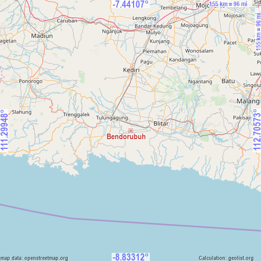
Bendorubuh GPS coordinates[2]
8° 8' 15.72" South, 112° 0' 9.36" East
| Map corner | latitude | longitude |
|---|---|---|
| Upper-left | -7.44107°, | 111.29948° |
| Center: | -8.1377°, | 112.0026° |
| Lower-right: | -8.83312°, | 112.70573° |
| Map W x H: | 154.8×154.8 km | = 96.2×96.2mi |
| max Lat: | 5.88969° ⇑67.7% North |
| Bendorubuh: | -8.1377° |
| min Lat: | ⇓32.3% South -10.934° |
| min Long | Bendorubuh | max Long |
| 95.1345° | 112.0026° | 140.9419° |
| W 50.1%⇐ | ⇒49.9% E |
Elevation
Elevation of Bendorubuh is 107 m = 351 ft, and this is 122.7 m = 403 ft below average elevation for this country.
| Max E: |
3185 m = 10449 ft | 48.7% |
| Avg. | 229.7 m = 754 ft | |
| Bendorubuh | 107 m = 351 ft | |
Min E: |
-1 m = -3 ft | 51.3% |
See also: Indonesia elevation on elevation.city.
Geographical zone
Bendorubuh is located in South Torrid zone (between Equator and Tropic of Capricorn). Distance of Equator is 904.8 km =562.2 mi to North.| Distance of | km | miles | from Bendorubuh |
|---|---|---|---|
| Equator | 904.8 | 562.2 | to North |
| Tropic Capricorn | 1701.1 | 1057 | to South |
| Antarctic Circle | 6496.3 | 4036.6 | to South |
| South Pole | 9102.2 | 5655.8 | to South |


Nearby cities:
15 places around Bendorubuh: (largest is in red/bold)
• Balesono
1.8 km =1.1 mi,  264°
264°
• Domasan
3 km =1.9 mi, 255°
• Karangsono
1.8 km =1.1 mi,  168°
168°
• Mirigambar
2.4 km =1.5 mi,  279°
279°
• Ngluweng Dua
3.4 km =2.1 mi,  183°
183°
• Padangan
3 km =1.9 mi,  70°
70°
• Pandansari
2.5 km =1.6 mi,  299°
299°
• Panjerrejo
1.7 km =1.1 mi,  91°
91°
• Salakan Lor
2.4 km =1.5 mi,  205°
205°
• Samir
1 km =0.6 mi,  187°
187°
• Selorejo
0.9 km =0.6 mi,  266°
266°
• Sumberingin Kulon
1.8 km =1.1 mi,  309°
309°
• Sumberjo Kulon
3.5 km =2.2 mi,  340°
340°
• Tenggong
3.4 km =2.1 mi,  129°
129°
• Tugu
3.1 km =1.9 mi,  95°
95°
Sources, notices
• [Note1] Compared only with cities in Indonesia existing in our database
• [Src1] Map data: © OpenStreetMap contributors (CC-BY-SA)
• [Src2] Other city data from geonames.org with taken over terms of usage.
• [Src3] Geographical zone / Annual Mean Temperature by Robert A. Rohde @ Wikipedia
