Bandung geodata
Bandung (East Java) is a seat of a fourth-order administrative division; located in Indonesia in Asia/Jakarta (GMT+7) time zone. In our database, there are 407 cities with bigger population. Compared to other cities in Indonesia, 69.1% of cities are located further ↑North; 54.4% of cities are located further ←West and 70.5% of cities have lower elevation than Bandung. Note1


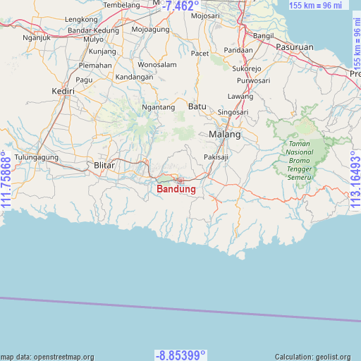
Bandung GPS coordinates[2]
8° 9' 30.96" South, 112° 27' 42.48" East
| Map corner | latitude | longitude |
|---|---|---|
| Upper-left | -7.462°, | 111.75868° |
| Center: | -8.1586°, | 112.4618° |
| Lower-right: | -8.85399°, | 113.16493° |
| Map W x H: | 154.8×154.8 km | = 96.2×96.2mi |
| max Lat: | 5.88969° ⇑69.1% North |
| Bandung: | -8.1586° |
| min Lat: | ⇓30.9% South -10.934° |
| min Long | Bandung | max Long |
| 95.1345° | 112.4618° | 140.9419° |
| W 54.4%⇐ | ⇒45.6% E |
Elevation
Elevation of Bandung is 299 m = 981 ft, and this is 69.3 m = 227 ft above average elevation for this country.
| Max E: |
3185 m = 10449 ft | 29.5% |
| Bandung | 299 m 981 ft | |
| Avg. | 229.7 m = 754 ft | |
Min E: |
-1 m = -3 ft | 70.5% |
See also: Indonesia elevation on elevation.city.
Geographical zone
Bandung is located in South Torrid zone (between Equator and Tropic of Capricorn). Distance of Equator is 907.2 km =563.7 mi to North.| Distance of | km | miles | from Bandung |
|---|---|---|---|
| Equator | 907.2 | 563.7 | to North |
| Tropic Capricorn | 1698.8 | 1055.6 | to South |
| Antarctic Circle | 6494 | 4035.2 | to South |
| South Pole | 9099.9 | 5654.4 | to South |


Nearby cities:
15 places around Bandung: (largest is in red/bold)
• Barisan
4.9 km =3 mi,  234°
234°
• Jarangan
5.9 km =3.7 mi,  343°
343°
• Jatirejo
4.6 km =2.9 mi,  40°
40°
• Kalipare
5.4 km =3.4 mi,  174°
174°
• Kertorejo
5.7 km =3.5 mi,  11°
11°
• Kopral
2.7 km =1.7 mi,  196°
196°
• Krajan
3.3 km =2.1 mi,  89°
89°
• Krajan
5.4 km =3.4 mi,  176°
176°
• Kromengan
4.6 km =2.9 mi,  45°
45°
• Ngreco
2.4 km =1.5 mi,  324°
324°
• Pohgajih
4.6 km =2.9 mi,  275°
275°
• Selorejo
4.5 km =2.8 mi,  298°
298°
• Senggreng
6 km =3.7 mi, 93°
• Sumberejo
3.8 km =2.4 mi,  313°
313°
• Sumberpucung
2.3 km =1.4 mi, 89°
Sources, notices
• [Note1] Compared only with cities in Indonesia existing in our database
• [Src1] Map data: © OpenStreetMap contributors (CC-BY-SA)
• [Src2] Other city data from geonames.org with taken over terms of usage.
• [Src3] Geographical zone / Annual Mean Temperature by Robert A. Rohde @ Wikipedia
