Kromengan geodata
Kromengan (East Java) is a seat of a third-order administrative division; located in Indonesia in Asia/Jakarta (GMT+7) time zone. In our database, there are 407 cities with bigger population. Compared to other cities in Indonesia, 67.2% of cities are located further ↑North; 54.8% of cities are located further ←West and 72.9% of cities have lower elevation than Kromengan. Note1


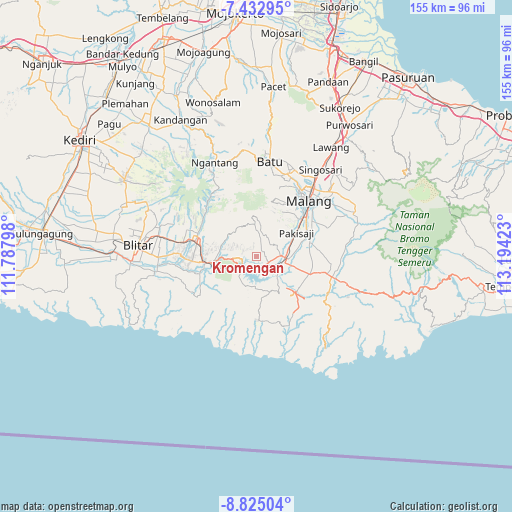
Kromengan GPS coordinates[2]
8° 7' 46.56" South, 112° 29' 27.96" East
| Map corner | latitude | longitude |
|---|---|---|
| Upper-left | -7.43295°, | 111.78798° |
| Center: | -8.1296°, | 112.4911° |
| Lower-right: | -8.82504°, | 113.19423° |
| Map W x H: | 154.8×154.8 km | = 96.2×96.2mi |
| max Lat: | 5.88969° ⇑67.2% North |
| Kromengan: | -8.1296° |
| min Lat: | ⇓32.8% South -10.934° |
| min Long | Kromengan | max Long |
| 95.1345° | 112.4911° | 140.9419° |
| W 54.8%⇐ | ⇒45.2% E |
Elevation
Elevation of Kromengan is 333 m = 1093 ft, and this is 103.3 m = 339 ft above average elevation for this country.
| Max E: |
3185 m = 10449 ft | 27.1% |
| Kromengan | 333 m 1093 ft | |
| Avg. | 229.7 m = 754 ft | |
Min E: |
-1 m = -3 ft | 72.9% |
See also: Indonesia elevation on elevation.city.
Geographical zone
Kromengan is located in South Torrid zone (between Equator and Tropic of Capricorn). Distance of Equator is 903.9 km =561.7 mi to North.| Distance of | km | miles | from Kromengan |
|---|---|---|---|
| Equator | 903.9 | 561.7 | to North |
| Tropic Capricorn | 1702 | 1057.6 | to South |
| Antarctic Circle | 6497.2 | 4037.2 | to South |
| South Pole | 9103.1 | 5656.4 | to South |


Nearby cities:
15 places around Kromengan: (largest is in red/bold)
• Bandung
4.6 km =2.9 mi,  225°
225°
• Bangelan
3.2 km =2 mi,  14°
14°
• Jambuwerkrajan
5.1 km =3.2 mi,  322°
322°
• Jatirejo
0.4 km =0.2 mi, 316°
• Kertorejo
3.2 km =2 mi, 317°
• Krajan
3.2 km =2 mi,  179°
179°
• Krandil
1.9 km =1.2 mi, 6°
• Ngebruk
3.6 km =2.2 mi,  129°
129°
• Ngreco
4.8 km =3 mi,  254°
254°
• Ngrejo
3.4 km =2.1 mi,  23°
23°
• Plandi
3.4 km =2.1 mi,  49°
49°
• Plaosan
5.1 km =3.2 mi,  34°
34°
• Selorok
4.1 km =2.5 mi,  112°
112°
• Senggreng
4.6 km =2.9 mi,  142°
142°
• Sumberpucung
3.3 km =2.1 mi,  195°
195°
Sources, notices
• [Note1] Compared only with cities in Indonesia existing in our database
• [Src1] Map data: © OpenStreetMap contributors (CC-BY-SA)
• [Src2] Other city data from geonames.org with taken over terms of usage.
• [Src3] Geographical zone / Annual Mean Temperature by Robert A. Rohde @ Wikipedia
