Resapombo geodata
Resapombo (East Java) is a seat of a fourth-order administrative division; located in Indonesia in Asia/Jakarta (GMT+7) time zone. In our database, there are 407 cities with bigger population. Compared to other cities in Indonesia, 63.1% of cities are located further ↑North; 53.6% of cities are located further ←West and 88.2% of cities have lower elevation than Resapombo. Note1


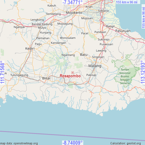
Resapombo GPS coordinates[2]
8° 2' 40.2" South, 112° 25' 7.68" East
| Map corner | latitude | longitude |
|---|---|---|
| Upper-left | -7.34771°, | 111.71568° |
| Center: | -8.0445°, | 112.4188° |
| Lower-right: | -8.74009°, | 113.12193° |
| Map W x H: | 154.8×154.8 km | = 96.2×96.2mi |
| max Lat: | 5.88969° ⇑63.1% North |
| Resapombo: | -8.0445° |
| min Lat: | ⇓36.9% South -10.934° |
| min Long | Resapombo | max Long |
| 95.1345° | 112.4188° | 140.9419° |
| W 53.6%⇐ | ⇒46.4% E |
Elevation
Elevation of Resapombo is 589 m = 1932 ft, and this is 359.3 m = 1179 ft above average elevation for this country.
| Max E: |
3185 m = 10449 ft | 11.8% |
| Resapombo | 589 m 1932 ft | |
| Avg. | 229.7 m = 754 ft | |
Min E: |
-1 m = -3 ft | 88.2% |
See also: Indonesia elevation on elevation.city.
Geographical zone
Resapombo is located in South Torrid zone (between Equator and Tropic of Capricorn). Distance of Equator is 894.5 km =555.8 mi to North.| Distance of | km | miles | from Resapombo |
|---|---|---|---|
| Equator | 894.5 | 555.8 | to North |
| Tropic Capricorn | 1711.5 | 1063.5 | to South |
| Antarctic Circle | 6506.7 | 4043.1 | to South |
| South Pole | 9112.6 | 5662.3 | to South |


Nearby cities:
15 places around Resapombo: (largest is in red/bold)
• Ampelgading
3 km =1.9 mi,  94°
94°
• Balerejo
4.9 km =3 mi,  288°
288°
• Bumirejo
1.9 km =1.2 mi,  148°
148°
• Cungkup
5.5 km =3.4 mi,  171°
171°
• Doko
6.5 km =4 mi,  230°
230°
• Jambuwerkrajan
7.3 km =4.5 mi,  138°
138°
• Kalimanis
2 km =1.2 mi, 91°
• Kemiri Gede
3.7 km =2.3 mi,  195°
195°
• Pakel
7.2 km =4.5 mi,  186°
186°
• Ringinrejo
5.5 km =3.4 mi,  218°
218°
• Sidomulyo
6.3 km =3.9 mi, 147°
• Sidorejo
5.4 km =3.4 mi, 232°
• Sumberingin
5.1 km =3.2 mi, 87°
• Tapakrejo
7.5 km =4.7 mi, 194°
• Tepas
6.5 km =4 mi, 204°
Sources, notices
• [Note1] Compared only with cities in Indonesia existing in our database
• [Src1] Map data: © OpenStreetMap contributors (CC-BY-SA)
• [Src2] Other city data from geonames.org with taken over terms of usage.
• [Src3] Geographical zone / Annual Mean Temperature by Robert A. Rohde @ Wikipedia
