Kepel geodata
Kepel (East Java) is a seat of a fourth-order administrative division; located in Indonesia in Asia/Jakarta (GMT+7) time zone. In our database, there are 407 cities with bigger population. Compared to other cities in Indonesia, 66.4% of cities are located further ↑North; 53.9% of cities are located further ←West and 73.5% of cities have lower elevation than Kepel. Note1


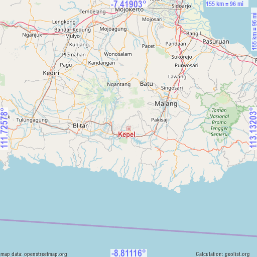
Kepel GPS coordinates[2]
8° 6' 56.52" South, 112° 25' 44.04" East
| Map corner | latitude | longitude |
|---|---|---|
| Upper-left | -7.41903°, | 111.72578° |
| Center: | -8.1157°, | 112.4289° |
| Lower-right: | -8.81116°, | 113.13203° |
| Map W x H: | 154.8×154.8 km | = 96.2×96.2mi |
| max Lat: | 5.88969° ⇑66.4% North |
| Kepel: | -8.1157° |
| min Lat: | ⇓33.6% South -10.934° |
| min Long | Kepel | max Long |
| 95.1345° | 112.4289° | 140.9419° |
| W 53.9%⇐ | ⇒46.1% E |
Elevation
Elevation of Kepel is 340 m = 1115 ft, and this is 110.3 m = 362 ft above average elevation for this country.
| Max E: |
3185 m = 10449 ft | 26.5% |
| Kepel | 340 m 1115 ft | |
| Avg. | 229.7 m = 754 ft | |
Min E: |
-1 m = -3 ft | 73.5% |
See also: Indonesia elevation on elevation.city.
Geographical zone
Kepel is located in South Torrid zone (between Equator and Tropic of Capricorn). Distance of Equator is 902.4 km =560.7 mi to North.| Distance of | km | miles | from Kepel |
|---|---|---|---|
| Equator | 902.4 | 560.7 | to North |
| Tropic Capricorn | 1703.5 | 1058.5 | to South |
| Antarctic Circle | 6498.8 | 4038.2 | to South |
| South Pole | 9104.7 | 5657.4 | to South |


Nearby cities:
15 places around Kepel: (largest is in red/bold)
• Cungkup
2.5 km =1.6 mi,  352°
352°
• Jambuwerkrajan
4.5 km =2.8 mi,  56°
56°
• Jarangan
2.1 km =1.3 mi,  65°
65°
• Kemiri Gede
4.8 km =3 mi,  334°
334°
• Kertorejo
4.8 km =3 mi,  80°
80°
• Ngreco
3.6 km =2.2 mi,  141°
141°
• Pakel
2.1 km =1.3 mi,  290°
290°
• Pohgajih
4.4 km =2.7 mi,  192°
192°
• Selorejo
2.6 km =1.6 mi, 187°
• Sembung
5.8 km =3.6 mi,  241°
241°
• Sidomulyo
3.4 km =2.1 mi,  41°
41°
• Sukoanyar
4.8 km =3 mi, 236°
• Sumberejo
2.3 km =1.4 mi,  158°
158°
• Tapakrejo
3.1 km =1.9 mi,  283°
283°
• Tepas
4.3 km =2.7 mi,  297°
297°
Sources, notices
• [Note1] Compared only with cities in Indonesia existing in our database
• [Src1] Map data: © OpenStreetMap contributors (CC-BY-SA)
• [Src2] Other city data from geonames.org with taken over terms of usage.
• [Src3] Geographical zone / Annual Mean Temperature by Robert A. Rohde @ Wikipedia
