Sukoanyar geodata
Sukoanyar (East Java) is a seat of a fourth-order administrative division; located in Indonesia in Asia/Jakarta (GMT+7) time zone. In our database, there are 407 cities with bigger population. Compared to other cities in Indonesia, 67.8% of cities are located further ↑North; 53.3% of cities are located further ←West and 65.4% of cities have lower elevation than Sukoanyar. Note1


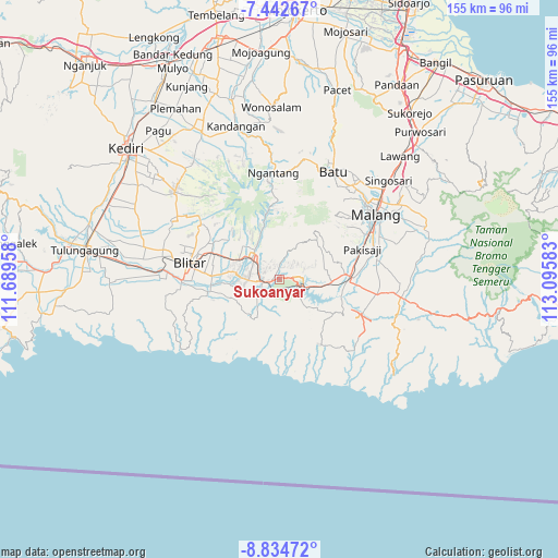
Sukoanyar GPS coordinates[2]
8° 8' 21.48" South, 112° 23' 33.72" East
| Map corner | latitude | longitude |
|---|---|---|
| Upper-left | -7.44267°, | 111.68958° |
| Center: | -8.1393°, | 112.3927° |
| Lower-right: | -8.83472°, | 113.09583° |
| Map W x H: | 154.8×154.8 km | = 96.2×96.2mi |
| max Lat: | 5.88969° ⇑67.8% North |
| Sukoanyar: | -8.1393° |
| min Lat: | ⇓32.2% South -10.934° |
| min Long | Sukoanyar | max Long |
| 95.1345° | 112.3927° | 140.9419° |
| W 53.3%⇐ | ⇒46.7% E |
Elevation
Elevation of Sukoanyar is 228 m = 748 ft, and this is 1.7 m = 6 ft below average elevation for this country.
| Max E: |
3185 m = 10449 ft | 34.6% |
| Avg. | 229.7 m = 754 ft | |
| Sukoanyar | 228 m = 748 ft | |
Min E: |
-1 m = -3 ft | 65.4% |
See also: Indonesia elevation on elevation.city.
Geographical zone
Sukoanyar is located in South Torrid zone (between Equator and Tropic of Capricorn). Distance of Equator is 905 km =562.3 mi to North.| Distance of | km | miles | from Sukoanyar |
|---|---|---|---|
| Equator | 905 | 562.3 | to North |
| Tropic Capricorn | 1700.9 | 1056.9 | to South |
| Antarctic Circle | 6496.2 | 4036.6 | to South |
| South Pole | 9102.1 | 5655.8 | to South |


Nearby cities:
15 places around Sukoanyar: (largest is in red/bold)
• Barisan
6.1 km =3.8 mi,  144°
144°
• Kepel
4.8 km =3 mi,  56°
56°
• Kesamben
3.1 km =1.9 mi,  255°
255°
• Krajan
1.9 km =1.2 mi,  289°
289°
• Ngadri
5.7 km =3.5 mi,  215°
215°
• Ngreco
6.2 km =3.9 mi,  91°
91°
• Pakel
3.9 km =2.4 mi,  31°
31°
• Pohgajih
3.5 km =2.2 mi,  119°
119°
• Selorejo
3.6 km =2.2 mi, 89°
• Sembung
1.1 km =0.7 mi, 260°
• Sumberejo
4.8 km =3 mi,  84°
84°
• Tapakrejo
3.5 km =2.2 mi,  16°
16°
• Tepas
4.6 km =2.9 mi,  2°
2°
• Tulungrejo
5.7 km =3.5 mi,  302°
302°
• Umbuldamar
6 km =3.7 mi, 221°
Sources, notices
• [Note1] Compared only with cities in Indonesia existing in our database
• [Src1] Map data: © OpenStreetMap contributors (CC-BY-SA)
• [Src2] Other city data from geonames.org with taken over terms of usage.
• [Src3] Geographical zone / Annual Mean Temperature by Robert A. Rohde @ Wikipedia
