Wedeng geodata
Wedeng (East Java) is a seat of a fourth-order administrative division; located in Indonesia in Asia/Jakarta (GMT+7) time zone. In our database, there are 407 cities with bigger population. Compared to other cities in Indonesia, 62.8% of cities are located further ↓South; 53.7% of cities are located further ←West and 98.5% of cities have higher elevation than Wedeng. Note1


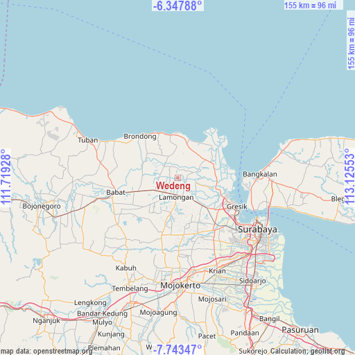
Wedeng GPS coordinates[2]
7° 2' 46.32" South, 112° 25' 20.64" East
| Map corner | latitude | longitude |
|---|---|---|
| Upper-left | -6.34788°, | 111.71928° |
| Center: | -7.0462°, | 112.4224° |
| Lower-right: | -7.74347°, | 113.12553° |
| Map W x H: | 155.2×155.2 km | = 96.4×96.4mi |
| max Lat: | 5.88969° ⇑37.2% North |
| Wedeng: | -7.0462° |
| min Lat: | ⇓62.8% South -10.934° |
| min Long | Wedeng | max Long |
| 95.1345° | 112.4224° | 140.9419° |
| W 53.7%⇐ | ⇒46.3% E |
Elevation
Elevation of Wedeng is 5 m = 16 ft, and this is 224.7 m = 737 ft below average elevation for this country.
| Max E: |
3185 m = 10449 ft | 98.5% |
| Avg. | 229.7 m = 754 ft | |
| Wedeng | 5 m = 16 ft | |
Min E: |
-1 m = -3 ft | 1.5% |
See also: Indonesia elevation on elevation.city.
Geographical zone
Wedeng is located in South Torrid zone (between Equator and Tropic of Capricorn). Distance of Equator is 783.5 km =486.8 mi to North.| Distance of | km | miles | from Wedeng |
|---|---|---|---|
| Equator | 783.5 | 486.8 | to North |
| Tropic Capricorn | 1822.5 | 1132.4 | to South |
| Antarctic Circle | 6617.7 | 4112 | to South |
| South Pole | 9223.6 | 5731.3 | to South |


Nearby cities:
15 places around Wedeng: (largest is in red/bold)
• Bambang
3.2 km =2 mi,  242°
242°
• Baru
3.6 km =2.2 mi,  258°
258°
• Blajo
3.2 km =2 mi,  275°
275°
• Gambuhan Kidul
2.7 km =1.7 mi,  286°
286°
• Gowa
1.9 km =1.2 mi, 261°
• Karang Kulon
0.5 km =0.3 mi,  157°
157°
• Kemlagigede
3.8 km =2.4 mi, 244°
• Ladan
2.9 km =1.8 mi,  133°
133°
• Lembung Lor
3.5 km =2.2 mi,  5°
5°
• Luntas
2.1 km =1.3 mi,  142°
142°
• Mayong Tengah
3.8 km =2.4 mi,  24°
24°
• Mlanggeng
3.3 km =2.1 mi, 164°
• Mlawe
0.5 km =0.3 mi,  170°
170°
• Ngujung
2 km =1.2 mi,  192°
192°
• Waru
1.9 km =1.2 mi,  268°
268°
Sources, notices
• [Note1] Compared only with cities in Indonesia existing in our database
• [Src1] Map data: © OpenStreetMap contributors (CC-BY-SA)
• [Src2] Other city data from geonames.org with taken over terms of usage.
• [Src3] Geographical zone / Annual Mean Temperature by Robert A. Rohde @ Wikipedia
