Lembung Lor geodata
Lembung Lor (East Java) is a seat of a fourth-order administrative division; located in Indonesia in Asia/Jakarta (GMT+7) time zone. In our database, there are 407 cities with bigger population. Compared to other cities in Indonesia, 64.9% of cities are located further ↓South; 53.8% of cities are located further ←West and 97.2% of cities have higher elevation than Lembung Lor. Note1


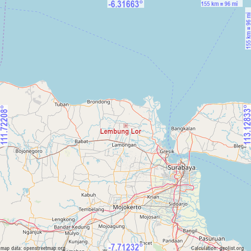
Lembung Lor GPS coordinates[2]
7° 0' 54" South, 112° 25' 30.72" East
| Map corner | latitude | longitude |
|---|---|---|
| Upper-left | -6.31663°, | 111.72208° |
| Center: | -7.015°, | 112.4252° |
| Lower-right: | -7.71232°, | 113.12833° |
| Map W x H: | 155.2×155.2 km | = 96.4×96.4mi |
| max Lat: | 5.88969° ⇑35.1% North |
| Lembung Lor: | -7.015° |
| min Lat: | ⇓64.9% South -10.934° |
| min Long | Lembung Lor | max Long |
| 95.1345° | 112.4252° | 140.9419° |
| W 53.8%⇐ | ⇒46.2% E |
Elevation
Elevation of Lembung Lor is 6 m = 20 ft, and this is 223.7 m = 734 ft below average elevation for this country.
| Max E: |
3185 m = 10449 ft | 97.2% |
| Avg. | 229.7 m = 754 ft | |
| Lembung Lor | 6 m = 20 ft | |
Min E: |
-1 m = -3 ft | 2.8% |
See also: Indonesia elevation on elevation.city.
Geographical zone
Lembung Lor is located in South Torrid zone (between Equator and Tropic of Capricorn). Distance of Equator is 780 km =484.7 mi to North.| Distance of | km | miles | from Lembung Lor |
|---|---|---|---|
| Equator | 780 | 484.7 | to North |
| Tropic Capricorn | 1825.9 | 1134.6 | to South |
| Antarctic Circle | 6621.2 | 4114.2 | to South |
| South Pole | 9227.1 | 5733.5 | to South |


Nearby cities:
15 places around Lembung Lor: (largest is in red/bold)
• Baron
3.1 km =1.9 mi,  85°
85°
• Canditunggal
1.6 km =1 mi,  338°
338°
• Depek
0.9 km =0.6 mi,  23°
23°
• Kalitengah
3.5 km =2.2 mi,  308°
308°
• Karang Kulon
4 km =2.5 mi,  181°
181°
• Kediren
3.1 km =1.9 mi,  315°
315°
• Kuluran
2.4 km =1.5 mi, 322°
• Lukrejo
3.5 km =2.2 mi,  261°
261°
• Madumulyorejo
3.2 km =2 mi,  53°
53°
• Mayong Tengah
1.3 km =0.8 mi, 87°
• Mlawe
4 km =2.5 mi, 183°
• Palangan
2.5 km =1.6 mi,  62°
62°
• Sumampir
2.6 km =1.6 mi, 50°
• Tiremenggal
1.9 km =1.2 mi,  3°
3°
• Wedeng
3.5 km =2.2 mi,  185°
185°
Sources, notices
• [Note1] Compared only with cities in Indonesia existing in our database
• [Src1] Map data: © OpenStreetMap contributors (CC-BY-SA)
• [Src2] Other city data from geonames.org with taken over terms of usage.
• [Src3] Geographical zone / Annual Mean Temperature by Robert A. Rohde @ Wikipedia
