Lukrejo geodata
Lukrejo (East Java) is a seat of a fourth-order administrative division; located in Indonesia in Asia/Jakarta (GMT+7) time zone. In our database, there are 407 cities with bigger population. Compared to other cities in Indonesia, 64.6% of cities are located further ↓South; 53.3% of cities are located further ←West and 97.2% of cities have higher elevation than Lukrejo. Note1


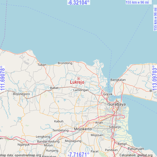
Lukrejo GPS coordinates[2]
7° 1' 9.84" South, 112° 23' 38.04" East
| Map corner | latitude | longitude |
|---|---|---|
| Upper-left | -6.32104°, | 111.69078° |
| Center: | -7.0194°, | 112.3939° |
| Lower-right: | -7.71671°, | 113.09703° |
| Map W x H: | 155.2×155.2 km | = 96.4×96.4mi |
| max Lat: | 5.88969° ⇑35.4% North |
| Lukrejo: | -7.0194° |
| min Lat: | ⇓64.6% South -10.934° |
| min Long | Lukrejo | max Long |
| 95.1345° | 112.3939° | 140.9419° |
| W 53.3%⇐ | ⇒46.7% E |
Elevation
Elevation of Lukrejo is 6 m = 20 ft, and this is 223.7 m = 734 ft below average elevation for this country.
| Max E: |
3185 m = 10449 ft | 97.2% |
| Avg. | 229.7 m = 754 ft | |
| Lukrejo | 6 m = 20 ft | |
Min E: |
-1 m = -3 ft | 2.8% |
See also: Indonesia elevation on elevation.city.
Geographical zone
Lukrejo is located in South Torrid zone (between Equator and Tropic of Capricorn). Distance of Equator is 780.5 km =485 mi to North.| Distance of | km | miles | from Lukrejo |
|---|---|---|---|
| Equator | 780.5 | 485 | to North |
| Tropic Capricorn | 1825.4 | 1134.3 | to South |
| Antarctic Circle | 6620.7 | 4113.9 | to South |
| South Pole | 9226.6 | 5733.1 | to South |


Nearby cities:
15 places around Lukrejo: (largest is in red/bold)
• Baru
3.7 km =2.3 mi,  186°
186°
• Blajo
2.7 km =1.7 mi,  181°
181°
• Butungan
2.9 km =1.8 mi,  0°
0°
• Canditunggal
3.5 km =2.2 mi,  54°
54°
• Dibee
2.3 km =1.4 mi,  347°
347°
• Gambuhan Kidul
2.3 km =1.4 mi,  167°
167°
• Gowa
3.5 km =2.2 mi,  159°
159°
• Kalitengah
2.8 km =1.7 mi,  15°
15°
• Kediren
3 km =1.9 mi,  25°
25°
• Kemendung
3.4 km =2.1 mi,  210°
210°
• Kuluran
3.1 km =1.9 mi,  40°
40°
• Lembung Lor
3.5 km =2.2 mi,  81°
81°
• Mungli
1.1 km =0.7 mi,  308°
308°
• Pangansalan
3.2 km =2 mi,  341°
341°
• Waru
3.3 km =2.1 mi, 158°
Sources, notices
• [Note1] Compared only with cities in Indonesia existing in our database
• [Src1] Map data: © OpenStreetMap contributors (CC-BY-SA)
• [Src2] Other city data from geonames.org with taken over terms of usage.
• [Src3] Geographical zone / Annual Mean Temperature by Robert A. Rohde @ Wikipedia
