Sekarputih geodata
Sekarputih (East Java) is a seat of a fourth-order administrative division; located in Indonesia in Asia/Jakarta (GMT+7) time zone. In our database, there are 407 cities with bigger population. Compared to other cities in Indonesia, 66.7% of cities are located further ↑North; 60.4% of cities are located further ←West and 62.4% of cities have higher elevation than Sekarputih. Note1


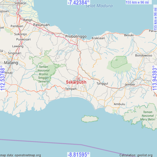
Sekarputih GPS coordinates[2]
8° 7' 13.8" South, 113° 14' 26.88" East
| Map corner | latitude | longitude |
|---|---|---|
| Upper-left | -7.42384°, | 112.53768° |
| Center: | -8.1205°, | 113.2408° |
| Lower-right: | -8.81595°, | 113.94393° |
| Map W x H: | 154.8×154.8 km | = 96.2×96.2mi |
| max Lat: | 5.88969° ⇑66.7% North |
| Sekarputih: | -8.1205° |
| min Lat: | ⇓33.3% South -10.934° |
| min Long | Sekarputih | max Long |
| 95.1345° | 113.2408° | 140.9419° |
| W 60.4%⇐ | ⇒39.6% E |
Elevation
Elevation of Sekarputih is 50 m = 164 ft, and this is 179.7 m = 590 ft below average elevation for this country.
| Max E: |
3185 m = 10449 ft | 62.4% |
| Avg. | 229.7 m = 754 ft | |
| Sekarputih | 50 m = 164 ft | |
Min E: |
-1 m = -3 ft | 37.6% |
See also: Indonesia elevation on elevation.city.
Geographical zone
Sekarputih is located in South Torrid zone (between Equator and Tropic of Capricorn). Distance of Equator is 902.9 km =561 mi to North.| Distance of | km | miles | from Sekarputih |
|---|---|---|---|
| Equator | 902.9 | 561 | to North |
| Tropic Capricorn | 1703 | 1058.2 | to South |
| Antarctic Circle | 6498.3 | 4037.9 | to South |
| South Pole | 9104.1 | 5657 | to South |


Nearby cities:
15 places around Sekarputih: (largest is in red/bold)
• Blukon
3.8 km =2.4 mi,  120°
120°
• Boreng
2.3 km =1.4 mi,  113°
113°
• Denok
3.9 km =2.4 mi,  147°
147°
• Kadipaten
3.2 km =2 mi,  238°
238°
• Krajan
2.9 km =1.8 mi,  314°
314°
• Krajan Baru
3.7 km =2.3 mi,  12°
12°
• Krajan Satu
3.6 km =2.2 mi,  295°
295°
• Krajan Wetan
3.6 km =2.2 mi,  2°
2°
• Lumajang
2.3 km =1.4 mi,  230°
230°
• Pandansari
3.5 km =2.2 mi,  161°
161°
• Pandanwangi
3.5 km =2.2 mi,  166°
166°
• Rogotrunan
1.4 km =0.9 mi,  276°
276°
• Sidodadi
2.8 km =1.7 mi, 303°
• Sukodono
2 km =1.2 mi,  331°
331°
• Wringinsari
4.3 km =2.7 mi,  263°
263°
Sources, notices
• [Note1] Compared only with cities in Indonesia existing in our database
• [Src1] Map data: © OpenStreetMap contributors (CC-BY-SA)
• [Src2] Other city data from geonames.org with taken over terms of usage.
• [Src3] Geographical zone / Annual Mean Temperature by Robert A. Rohde @ Wikipedia
