Lumajang geodata
Lumajang (East Java) is a seat of a second-order administrative division; located in Indonesia in Asia/Jakarta (GMT+7) time zone. With population of 123,626 people, there are 105 cities with bigger population in this country. Compared to other cities in Indonesia, 67.4% of cities are located further ↑North; 60.3% of cities are located further ←West and 60.8% of cities have higher elevation than Lumajang. Note1


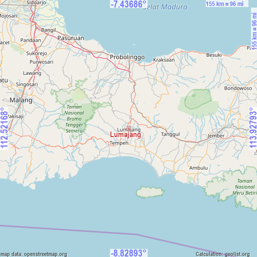
Lumajang GPS coordinates[2]
8° 8' 0.6" South, 113° 13' 29.28" East
| Map corner | latitude | longitude |
|---|---|---|
| Upper-left | -7.43686°, | 112.52168° |
| Center: | -8.1335°, | 113.2248° |
| Lower-right: | -8.82893°, | 113.92793° |
| Map W x H: | 154.8×154.8 km | = 96.2×96.2mi |
| max Lat: | 5.88969° ⇑67.4% North |
| Lumajang: | -8.1335° |
| min Lat: | ⇓32.6% South -10.934° |
| min Long | Lumajang | max Long |
| 95.1345° | 113.2248° | 140.9419° |
| W 60.3%⇐ | ⇒39.7% E |
Elevation
Elevation of Lumajang is 56 m = 184 ft, and this is 173.7 m = 570 ft below average elevation for this country.
| Max E: |
3185 m = 10449 ft | 60.8% |
| Avg. | 229.7 m = 754 ft | |
| Lumajang | 56 m = 184 ft | |
Min E: |
-1 m = -3 ft | 39.2% |
See also: Lumajang elevation on elevation.city.
Geographical zone
Lumajang is located in South Torrid zone (between Equator and Tropic of Capricorn). Distance of Equator is 904.4 km =562 mi to North.| Distance of | km | miles | from Lumajang |
|---|---|---|---|
| Equator | 904.4 | 562 | to North |
| Tropic Capricorn | 1701.6 | 1057.3 | to South |
| Antarctic Circle | 6496.8 | 4036.9 | to South |
| South Pole | 9102.7 | 5656.2 | to South |


Nearby cities:
15 places around Lumajang: (largest is in red/bold)
• Gedongsari
3.3 km =2.1 mi,  239°
239°
• Grati Satu
2.3 km =1.4 mi,  199°
199°
• Kadipaten
1 km =0.6 mi,  256°
256°
• Krajan
3.2 km =2 mi,  308°
308°
• Krajan
3.5 km =2.2 mi,  354°
354°
• Krajan Satu
3.3 km =2.1 mi,  333°
333°
• Laban
2.5 km =1.6 mi,  248°
248°
• Pandansari
3.4 km =2.1 mi,  123°
123°
• Pandanwangi
3.2 km =2 mi,  126°
126°
• Rogotrunan
1.6 km =1 mi,  13°
13°
• Sarirejo Satu
3.8 km =2.4 mi,  227°
227°
• Sekarputih
2.3 km =1.4 mi,  50°
50°
• Sidodadi
3.1 km =1.9 mi, 348°
• Sukodono
3.3 km =2.1 mi, 14°
• Wringinsari
2.7 km =1.7 mi,  291°
291°
Sources, notices
• [Note1] Compared only with cities in Indonesia existing in our database
• [Src1] Map data: © OpenStreetMap contributors (CC-BY-SA)
• [Src2] Other city data from geonames.org with taken over terms of usage.
• [Src3] Geographical zone / Annual Mean Temperature by Robert A. Rohde @ Wikipedia
