Tengah geodata
Tengah (Bali) is a seat of a fourth-order administrative division; located in Indonesia in Asia/Makassar (GMT+8) time zone. In our database, there are 407 cities with bigger population. Compared to other cities in Indonesia, 74.9% of cities are located further ↑North; 70.9% of cities are located further ←West and 84% of cities have lower elevation than Tengah. Note1


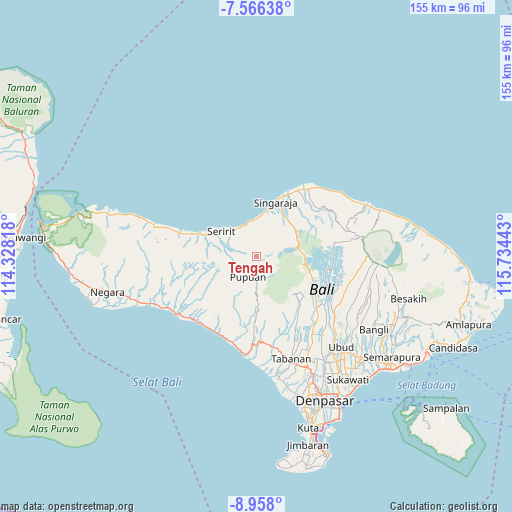
Tengah GPS coordinates[2]
8° 15' 46.08" South, 115° 1' 52.68" East
| Map corner | latitude | longitude |
|---|---|---|
| Upper-left | -7.56638°, | 114.32818° |
| Center: | -8.2628°, | 115.0313° |
| Lower-right: | -8.958°, | 115.73443° |
| Map W x H: | 154.7×154.7 km | = 96.1×96.1mi |
| max Lat: | 5.88969° ⇑74.9% North |
| Tengah: | -8.2628° |
| min Lat: | ⇓25.1% South -10.934° |
| min Long | Tengah | max Long |
| 95.1345° | 115.0313° | 140.9419° |
| W 70.9%⇐ | ⇒29.1% E |
Elevation
Elevation of Tengah is 499 m = 1637 ft, and this is 269.3 m = 884 ft above average elevation for this country.
| Max E: |
3185 m = 10449 ft | 16% |
| Tengah | 499 m 1637 ft | |
| Avg. | 229.7 m = 754 ft | |
Min E: |
-1 m = -3 ft | 84% |
See also: Indonesia elevation on elevation.city.
Geographical zone
Tengah is located in South Torrid zone (between Equator and Tropic of Capricorn). Distance of Equator is 918.7 km =570.9 mi to North.| Distance of | km | miles | from Tengah |
|---|---|---|---|
| Equator | 918.7 | 570.9 | to North |
| Tropic Capricorn | 1687.2 | 1048.4 | to South |
| Antarctic Circle | 6482.4 | 4028 | to South |
| South Pole | 9088.3 | 5647.2 | to South |


Nearby cities:
15 places around Tengah: (largest is in red/bold)
• Banjar Cempaga
5.1 km =3.2 mi,  333°
333°
• Banjar Dauhpura
6.8 km =4.2 mi,  352°
352°
• Banjar Pedawa
3 km =1.9 mi, 348°
• Banjar Tamansari
3.8 km =2.4 mi,  300°
300°
• Banjarsari
5.3 km =3.3 mi,  292°
292°
• Bantiran
6.8 km =4.2 mi,  220°
220°
• Bestala
6.2 km =3.9 mi, 287°
• Dajanpura
6.3 km =3.9 mi,  322°
322°
• Kanginan
6.1 km =3.8 mi,  243°
243°
• Kauhan
6.6 km =4.1 mi,  265°
265°
• Munduk
5.3 km =3.3 mi,  97°
97°
• Pelapuan
4.7 km =2.9 mi,  264°
264°
• Puspajati
4.2 km =2.6 mi,  276°
276°
• Subuk
6.6 km =4.1 mi,  245°
245°
• Taman
0.5 km =0.3 mi,  44°
44°
Sources, notices
• [Note1] Compared only with cities in Indonesia existing in our database
• [Src1] Map data: © OpenStreetMap contributors (CC-BY-SA)
• [Src2] Other city data from geonames.org with taken over terms of usage.
• [Src3] Geographical zone / Annual Mean Temperature by Robert A. Rohde @ Wikipedia
