Jubung geodata
Jubung (East Java) is a seat of a fourth-order administrative division; located in Indonesia in Asia/Jakarta (GMT+7) time zone. In our database, there are 407 cities with bigger population. Compared to other cities in Indonesia, 71.3% of cities are located further ↑North; 63.9% of cities are located further ←West and 59.1% of cities have higher elevation than Jubung. Note1


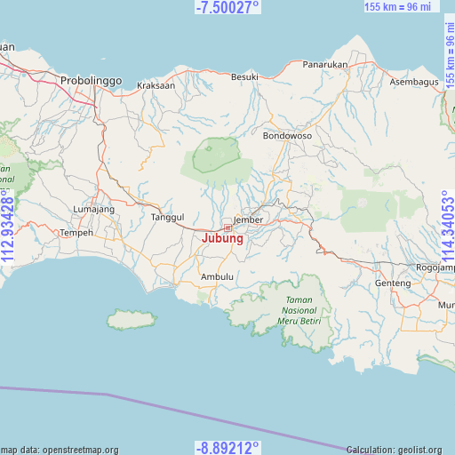
Jubung GPS coordinates[2]
8° 11' 48.48" South, 113° 38' 14.64" East
| Map corner | latitude | longitude |
|---|---|---|
| Upper-left | -7.50027°, | 112.93428° |
| Center: | -8.1968°, | 113.6374° |
| Lower-right: | -8.89212°, | 114.34053° |
| Map W x H: | 154.8×154.8 km | = 96.2×96.2mi |
| max Lat: | 5.88969° ⇑71.3% North |
| Jubung: | -8.1968° |
| min Lat: | ⇓28.7% South -10.934° |
| min Long | Jubung | max Long |
| 95.1345° | 113.6374° | 140.9419° |
| W 63.9%⇐ | ⇒36.1% E |
Elevation
Elevation of Jubung is 63 m = 207 ft, and this is 166.7 m = 547 ft below average elevation for this country.
| Max E: |
3185 m = 10449 ft | 59.1% |
| Avg. | 229.7 m = 754 ft | |
| Jubung | 63 m = 207 ft | |
Min E: |
-1 m = -3 ft | 40.9% |
See also: Indonesia elevation on elevation.city.
Geographical zone
Jubung is located in South Torrid zone (between Equator and Tropic of Capricorn). Distance of Equator is 911.4 km =566.3 mi to North.| Distance of | km | miles | from Jubung |
|---|---|---|---|
| Equator | 911.4 | 566.3 | to North |
| Tropic Capricorn | 1694.5 | 1052.9 | to South |
| Antarctic Circle | 6489.8 | 4032.6 | to South |
| South Pole | 9095.7 | 5651.8 | to South |


Nearby cities:
15 places around Jubung: (largest is in red/bold)
• Ajung
2.3 km =1.4 mi,  116°
116°
• Bedadung Kulon
4.2 km =2.6 mi,  232°
232°
• Dukuhmencek Lor
3.3 km =2.1 mi,  22°
22°
• Dukuhsia
2.1 km =1.3 mi,  274°
274°
• Glagahwero
3 km =1.9 mi,  317°
317°
• Gugut
3.1 km =1.9 mi,  297°
297°
• Kaliwates
4.1 km =2.5 mi,  66°
66°
• Kemuningsari
4.5 km =2.8 mi, 303°
• Klompangan
4.5 km =2.8 mi,  156°
156°
• Krajan
3.3 km =2.1 mi, 67°
• Krasak
3.3 km =2.1 mi,  142°
142°
• Mangli
1.7 km =1.1 mi, 67°
• Panti
3.5 km =2.2 mi,  338°
338°
• Rambipuji
3.4 km =2.1 mi,  246°
246°
• Serut
4.9 km =3 mi,  0°
0°
Sources, notices
• [Note1] Compared only with cities in Indonesia existing in our database
• [Src1] Map data: © OpenStreetMap contributors (CC-BY-SA)
• [Src2] Other city data from geonames.org with taken over terms of usage.
• [Src3] Geographical zone / Annual Mean Temperature by Robert A. Rohde @ Wikipedia
