Kluncing geodata
Kluncing (East Java) is a seat of a fourth-order administrative division; located in Indonesia in Asia/Jakarta (GMT+7) time zone. In our database, there are 407 cities with bigger population. Compared to other cities in Indonesia, 71% of cities are located further ↑North; 68.6% of cities are located further ←West and 83.9% of cities have lower elevation than Kluncing. Note1


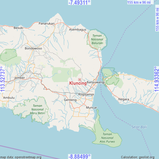
Kluncing GPS coordinates[2]
8° 11' 22.776" South, 114° 13' 49.764" East
| Map corner | latitude | longitude |
|---|---|---|
| Upper-left | -7.49311°, | 113.52737° |
| Center: | -8.18966°, | 114.23049° |
| Lower-right: | -8.88499°, | 114.93362° |
| Map W x H: | 154.8×154.8 km | = 96.2×96.2mi |
| max Lat: | 5.88969° ⇑71% North |
| Kluncing: | -8.18966° |
| min Lat: | ⇓29% South -10.934° |
| min Long | Kluncing | max Long |
| 95.1345° | 114.23049° | 140.9419° |
| W 68.6%⇐ | ⇒31.4% E |
Elevation
Elevation of Kluncing is 498 m = 1634 ft, and this is 268.3 m = 880 ft above average elevation for this country.
| Max E: |
3185 m = 10449 ft | 16.1% |
| Kluncing | 498 m 1634 ft | |
| Avg. | 229.7 m = 754 ft | |
Min E: |
-1 m = -3 ft | 83.9% |
See also: Indonesia elevation on elevation.city.
Geographical zone
Kluncing is located in South Torrid zone (between Equator and Tropic of Capricorn). Distance of Equator is 910.6 km =565.8 mi to North.| Distance of | km | miles | from Kluncing |
|---|---|---|---|
| Equator | 910.6 | 565.8 | to North |
| Tropic Capricorn | 1695.3 | 1053.4 | to South |
| Antarctic Circle | 6490.6 | 4033.1 | to South |
| South Pole | 9096.5 | 5652.3 | to South |


Nearby cities:
15 places around Kluncing: (largest is in red/bold)
• Krajan
0.9 km =0.6 mi,  191°
191°
• Krajan
4 km =2.5 mi,  95°
95°
• Krajan
4.7 km =2.9 mi,  112°
112°
• Krajan
6 km =3.7 mi,  72°
72°
• Krajan
6.1 km =3.8 mi,  117°
117°
• Krajan
6.7 km =4.2 mi, 124°
• Krajan
7.5 km =4.7 mi, 95°
• Krajan
7.5 km =4.7 mi,  200°
200°
• Krajan
7.7 km =4.8 mi, 106°
• Plataran
5 km =3.1 mi,  226°
226°
• Songgon
5.8 km =3.6 mi,  209°
209°
• Songgon Krajan
5.9 km =3.7 mi, 206°
• Sragikrajan
8.6 km =5.3 mi, 230°
• Sumberagung
7.1 km =4.4 mi,  244°
244°
• Tambakbayan
8.5 km =5.3 mi,  176°
176°
Sources, notices
• [Note1] Compared only with cities in Indonesia existing in our database
• [Src1] Map data: © OpenStreetMap contributors (CC-BY-SA)
• [Src2] Other city data from geonames.org with taken over terms of usage.
• [Src3] Geographical zone / Annual Mean Temperature by Robert A. Rohde @ Wikipedia
