Songgon geodata
Songgon (East Java) is a seat of a third-order administrative division; located in Indonesia in Asia/Jakarta (GMT+7) time zone. In our database, there are 407 cities with bigger population. Compared to other cities in Indonesia, 73.5% of cities are located further ↑North; 68.4% of cities are located further ←West and 74.2% of cities have lower elevation than Songgon. Note1


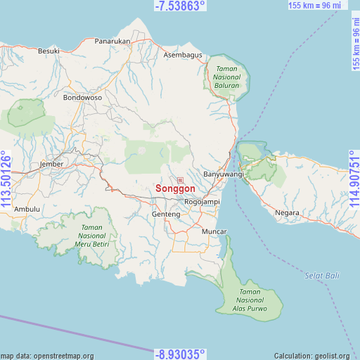
Songgon GPS coordinates[2]
8° 14' 6.36" South, 114° 12' 15.768" East
| Map corner | latitude | longitude |
|---|---|---|
| Upper-left | -7.53863°, | 113.50126° |
| Center: | -8.2351°, | 114.20438° |
| Lower-right: | -8.93035°, | 114.90751° |
| Map W x H: | 154.7×154.7 km | = 96.1×96.1mi |
| max Lat: | 5.88969° ⇑73.5% North |
| Songgon: | -8.2351° |
| min Lat: | ⇓26.5% South -10.934° |
| min Long | Songgon | max Long |
| 95.1345° | 114.20438° | 140.9419° |
| W 68.4%⇐ | ⇒31.6% E |
Elevation
Elevation of Songgon is 348 m = 1142 ft, and this is 118.3 m = 388 ft above average elevation for this country.
| Max E: |
3185 m = 10449 ft | 25.8% |
| Songgon | 348 m 1142 ft | |
| Avg. | 229.7 m = 754 ft | |
Min E: |
-1 m = -3 ft | 74.2% |
See also: Indonesia elevation on elevation.city.
Geographical zone
Songgon is located in South Torrid zone (between Equator and Tropic of Capricorn). Distance of Equator is 915.7 km =569 mi to North.| Distance of | km | miles | from Songgon |
|---|---|---|---|
| Equator | 915.7 | 569 | to North |
| Tropic Capricorn | 1690.3 | 1050.3 | to South |
| Antarctic Circle | 6485.5 | 4029.9 | to South |
| South Pole | 9091.4 | 5649.1 | to South |


Nearby cities:
15 places around Songgon: (largest is in red/bold)
• Cantuk Kidul
7.5 km =4.7 mi,  160°
160°
• Kluncing
5.8 km =3.6 mi,  29°
29°
• Krajan
2 km =1.2 mi,  173°
173°
• Krajan
5 km =3.1 mi, 32°
• Krajan
7.5 km =4.7 mi,  146°
146°
• Krajan
7.7 km =4.8 mi,  175°
175°
• Krajan
7.9 km =4.9 mi,  65°
65°
• Plataran
1.8 km =1.1 mi,  335°
335°
• Rukem
6.8 km =4.2 mi, 173°
• Songgon Krajan
0.3 km =0.2 mi,  139°
139°
• Sragikrajan
3.8 km =2.4 mi,  262°
262°
• Sumberagung
4 km =2.5 mi,  299°
299°
• Sumberarumkrajan
5.8 km =3.6 mi,  294°
294°
• Tambakbayan
4.8 km =3 mi,  134°
134°
• Wiyayu Barat
6.3 km =3.9 mi, 161°
Sources, notices
• [Note1] Compared only with cities in Indonesia existing in our database
• [Src1] Map data: © OpenStreetMap contributors (CC-BY-SA)
• [Src2] Other city data from geonames.org with taken over terms of usage.
• [Src3] Geographical zone / Annual Mean Temperature by Robert A. Rohde @ Wikipedia
