Banjar Kelodan geodata
Banjar Kelodan (Bali) is a seat of a fourth-order administrative division; located in Indonesia in Asia/Makassar (GMT+8) time zone. In our database, there are 407 cities with bigger population. Compared to other cities in Indonesia, 82.3% of cities are located further ↑North; 75.2% of cities are located further ←West and 57.4% of cities have lower elevation than Banjar Kelodan. Note1


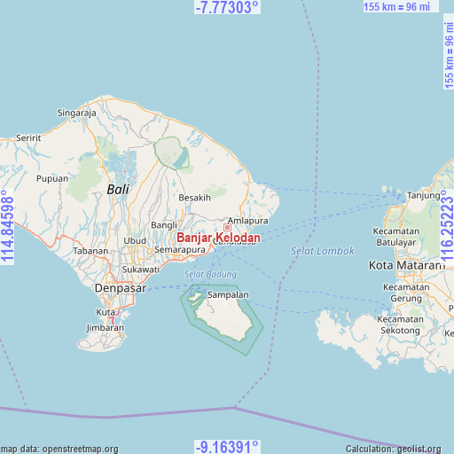
Banjar Kelodan GPS coordinates[2]
8° 28' 8.76" South, 115° 32' 56.76" East
| Map corner | latitude | longitude |
|---|---|---|
| Upper-left | -7.77303°, | 114.84598° |
| Center: | -8.4691°, | 115.5491° |
| Lower-right: | -9.16391°, | 116.25223° |
| Map W x H: | 154.7×154.7 km | = 96.1×96.1mi |
| max Lat: | 5.88969° ⇑82.3% North |
| Banjar Kelodan: | -8.4691° |
| min Lat: | ⇓17.7% South -10.934° |
| min Long | Banjar Kelodan | max Long |
| 95.1345° | 115.5491° | 140.9419° |
| W 75.2%⇐ | ⇒24.8% E |
Elevation
Elevation of Banjar Kelodan is 141 m = 463 ft, and this is 88.7 m = 291 ft below average elevation for this country.
| Max E: |
3185 m = 10449 ft | 42.6% |
| Avg. | 229.7 m = 754 ft | |
| Banjar Kelodan | 141 m = 463 ft | |
Min E: |
-1 m = -3 ft | 57.4% |
See also: Indonesia elevation on elevation.city.
Geographical zone
Banjar Kelodan is located in South Torrid zone (between Equator and Tropic of Capricorn). Distance of Equator is 941.7 km =585.1 mi to North.| Distance of | km | miles | from Banjar Kelodan |
|---|---|---|---|
| Equator | 941.7 | 585.1 | to North |
| Tropic Capricorn | 1664.2 | 1034.1 | to South |
| Antarctic Circle | 6459.5 | 4013.7 | to South |
| South Pole | 9065.4 | 5633 | to South |


Nearby cities:
15 places around Banjar Kelodan: (largest is in red/bold)
• Banjar Beji
3.8 km =2.4 mi,  71°
71°
• Banjar Budakeling
5.2 km =3.2 mi,  28°
28°
• Banjar Bugbug
5.4 km =3.4 mi,  114°
114°
• Banjar Desa Tengah
3.6 km =2.2 mi, 25°
• Banjar Jungutan
4.2 km =2.6 mi,  340°
340°
• Banjar Kawan
3.5 km =2.2 mi,  231°
231°
• Banjar Pegeringsingan
2.1 km =1.3 mi, 110°
• Banjar Tengah
1.4 km =0.9 mi,  243°
243°
• Banjar Tengah
2.9 km =1.8 mi,  333°
333°
• Banjar Tengah
5.7 km =3.5 mi, 234°
• Banjar Timbrah
5.3 km =3.3 mi,  99°
99°
• Banjar Wates Tengah
5.8 km =3.6 mi,  293°
293°
• Bebandem
3.6 km =2.2 mi,  21°
21°
• Bedugul
5.2 km =3.2 mi, 66°
• Ulakan
5.1 km =3.2 mi, 231°
Sources, notices
• [Note1] Compared only with cities in Indonesia existing in our database
• [Src1] Map data: © OpenStreetMap contributors (CC-BY-SA)
• [Src2] Other city data from geonames.org with taken over terms of usage.
• [Src3] Geographical zone / Annual Mean Temperature by Robert A. Rohde @ Wikipedia
