Legian geodata
Legian (Bali) is a populated place; located in Indonesia in Asia/Makassar (GMT+8) time zone. With population of 10,000 people, there are 376 cities with bigger population in this country. Compared to other cities in Indonesia, 89.4% of cities are located further ↑North; 72.3% of cities are located further ←West and 93.7% of cities have higher elevation than Legian. Note1


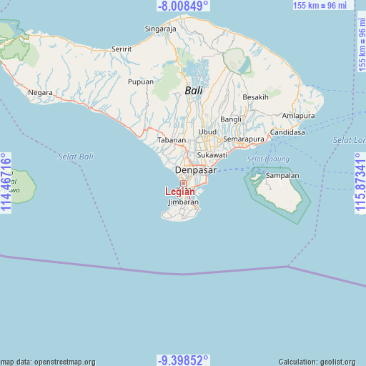
Legian GPS coordinates[2]
8° 42' 14.94" South, 115° 10' 13.008" East
| Map corner | latitude | longitude |
|---|---|---|
| Upper-left | -8.00849°, | 114.46716° |
| Center: | -8.70415°, | 115.17028° |
| Lower-right: | -9.39852°, | 115.87341° |
| Map W x H: | 154.6×154.6 km | = 96.1×96.1mi |
| max Lat: | 5.88969° ⇑89.4% North |
| Legian: | -8.70415° |
| min Lat: | ⇓10.6% South -10.934° |
| min Long | Legian | max Long |
| 95.1345° | 115.17028° | 140.9419° |
| W 72.3%⇐ | ⇒27.7% E |
Elevation
Elevation of Legian is 8 m = 26 ft, and this is 221.7 m = 727 ft below average elevation for this country.
| Max E: |
3185 m = 10449 ft | 93.7% |
| Avg. | 229.7 m = 754 ft | |
| Legian | 8 m = 26 ft | |
Min E: |
-1 m = -3 ft | 6.3% |
See also: Indonesia elevation on elevation.city.
Geographical zone
Legian is located in South Torrid zone (between Equator and Tropic of Capricorn). Distance of Equator is 967.8 km =601.4 mi to North.| Distance of | km | miles | from Legian |
|---|---|---|---|
| Equator | 967.8 | 601.4 | to North |
| Tropic Capricorn | 1638.1 | 1017.9 | to South |
| Antarctic Circle | 6433.4 | 3997.5 | to South |
| South Pole | 9039.3 | 5616.8 | to South |


Nearby cities:
15 places around Legian: (largest is in red/bold)
• Banjar Batanpoh
10.1 km =6.3 mi,  72°
72°
• Banjar Gunungpande
10.2 km =6.3 mi,  344°
344°
• Banjar Kayangan
11.2 km =7 mi,  35°
35°
• Banjar Kerobokan
10.6 km =6.6 mi,  333°
333°
• Banjar Kertasari
10.1 km =6.3 mi,  25°
25°
• Banjar Medura
9.2 km =5.7 mi,  81°
81°
• Banjar Pemangkalan
9.5 km =5.9 mi,  20°
20°
• Banjar Taman
9.8 km =6.1 mi, 75°
• Dajan Tangluk
9.9 km =6.2 mi,  49°
49°
• Denpasar
7.9 km =4.9 mi, 40°
• Jabajero
2.7 km =1.7 mi,  168°
168°
• Jimbaran
9.7 km =6 mi,  186°
186°
• Karyadharma
5.3 km =3.3 mi,  89°
89°
• Kelanabian
5.4 km =3.4 mi, 172°
• Kuta
2.1 km =1.3 mi, 173°
Sources, notices
• [Note1] Compared only with cities in Indonesia existing in our database
• [Src1] Map data: © OpenStreetMap contributors (CC-BY-SA)
• [Src2] Other city data from geonames.org with taken over terms of usage.
• [Src3] Geographical zone / Annual Mean Temperature by Robert A. Rohde @ Wikipedia
