Gumiring geodata
Gumiring (Central Java) is a seat of a fourth-order administrative division; located in Indonesia in Asia/Jakarta (GMT+7) time zone. In our database, there are 407 cities with bigger population. Compared to other cities in Indonesia, 63.6% of cities are located further ↓South; 60.6% of cities are located further →East and 53.7% of cities have higher elevation than Gumiring. Note1


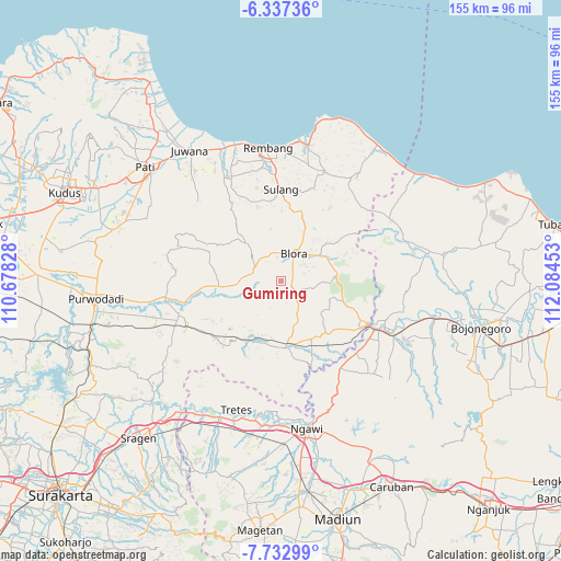
Gumiring GPS coordinates[2]
7° 2' 8.52" South, 111° 22' 53.04" East
| Map corner | latitude | longitude |
|---|---|---|
| Upper-left | -6.33736°, | 110.67828° |
| Center: | -7.0357°, | 111.3814° |
| Lower-right: | -7.73299°, | 112.08453° |
| Map W x H: | 155.2×155.2 km | = 96.4×96.4mi |
| max Lat: | 5.88969° ⇑36.4% North |
| Gumiring: | -7.0357° |
| min Lat: | ⇓63.6% South -10.934° |
| min Long | Gumiring | max Long |
| 95.1345° | 111.3814° | 140.9419° |
| W 39.4%⇐ | ⇒60.6% E |
Elevation
Elevation of Gumiring is 90 m = 295 ft, and this is 139.7 m = 458 ft below average elevation for this country.
| Max E: |
3185 m = 10449 ft | 53.7% |
| Avg. | 229.7 m = 754 ft | |
| Gumiring | 90 m = 295 ft | |
Min E: |
-1 m = -3 ft | 46.3% |
See also: Indonesia elevation on elevation.city.
Geographical zone
Gumiring is located in South Torrid zone (between Equator and Tropic of Capricorn). Distance of Equator is 782.3 km =486.1 mi to North.| Distance of | km | miles | from Gumiring |
|---|---|---|---|
| Equator | 782.3 | 486.1 | to North |
| Tropic Capricorn | 1823.6 | 1133.1 | to South |
| Antarctic Circle | 6618.9 | 4112.8 | to South |
| South Pole | 9224.8 | 5732 | to South |


Nearby cities:
15 places around Gumiring: (largest is in red/bold)
• Bacem
3.1 km =1.9 mi,  246°
246°
• Badong
4.5 km =2.8 mi,  39°
39°
• Balongrejo
3.1 km =1.9 mi,  338°
338°
• Banjarejo
4.1 km =2.5 mi,  272°
272°
• Boto
3.6 km =2.2 mi,  13°
13°
• Jepang Satu
5 km =3.1 mi,  61°
61°
• Karangtalun
3.7 km =2.3 mi,  297°
297°
• Klopoduwur
3.2 km =2 mi,  72°
72°
• Kulonkali
5.1 km =3.2 mi,  351°
351°
• Mojo Wetan
1.6 km =1 mi,  290°
290°
• Ngablak
2 km =1.2 mi,  17°
17°
• Pruntusan
5.2 km =3.2 mi,  312°
312°
• Sambirejo
4.8 km =3 mi,  256°
256°
• Sembungin
4.2 km =2.6 mi, 339°
• Sendanggayam
4 km =2.5 mi, 260°
Sources, notices
• [Note1] Compared only with cities in Indonesia existing in our database
• [Src1] Map data: © OpenStreetMap contributors (CC-BY-SA)
• [Src2] Other city data from geonames.org with taken over terms of usage.
• [Src3] Geographical zone / Annual Mean Temperature by Robert A. Rohde @ Wikipedia
