Nuasepu geodata
Nuasepu (East Nusa Tenggara) is a seat of a fourth-order administrative division; located in Indonesia in Asia/Makassar (GMT+8) time zone. In our database, there are 407 cities with bigger population. Compared to other cities in Indonesia, 91.3% of cities are located further ↑North; 86.9% of cities are located further ←West and 85.8% of cities have lower elevation than Nuasepu. Note1


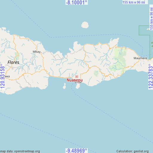
Nuasepu GPS coordinates[2]
8° 47' 43.8" South, 121° 38' 4.92" East
| Map corner | latitude | longitude |
|---|---|---|
| Upper-left | -8.10001°, | 120.93158° |
| Center: | -8.7955°, | 121.6347° |
| Lower-right: | -9.48969°, | 122.33783° |
| Map W x H: | 154.5×154.5 km | = 96×96mi |
| max Lat: | 5.88969° ⇑91.3% North |
| Nuasepu: | -8.7955° |
| min Lat: | ⇓8.7% South -10.934° |
| min Long | Nuasepu | max Long |
| 95.1345° | 121.6347° | 140.9419° |
| W 86.9%⇐ | ⇒13.1% E |
Elevation
Elevation of Nuasepu is 533 m = 1749 ft, and this is 303.3 m = 995 ft above average elevation for this country.
| Max E: |
3185 m = 10449 ft | 14.2% |
| Nuasepu | 533 m 1749 ft | |
| Avg. | 229.7 m = 754 ft | |
Min E: |
-1 m = -3 ft | 85.8% |
See also: Indonesia elevation on elevation.city.
Geographical zone
Nuasepu is located in South Torrid zone (between Equator and Tropic of Capricorn). Distance of Equator is 978 km =607.7 mi to North.| Distance of | km | miles | from Nuasepu |
|---|---|---|---|
| Equator | 978 | 607.7 | to North |
| Tropic Capricorn | 1628 | 1011.6 | to South |
| Antarctic Circle | 6423.2 | 3991.2 | to South |
| South Pole | 9029.1 | 5610.4 | to South |


Nearby cities:
15 places around Nuasepu: (largest is in red/bold)
• Aefeo
5.6 km =3.5 mi,  50°
50°
• Aemura
4 km =2.5 mi,  111°
111°
• Baraiwena
4.4 km =2.7 mi,  230°
230°
• Detumbawa
4.3 km =2.7 mi,  75°
75°
• Kombandaru
3.6 km =2.2 mi,  285°
285°
• Lokoboko
5.7 km =3.5 mi,  117°
117°
• Mbomba
4 km =2.5 mi,  203°
203°
• Mbongawani
5.8 km =3.6 mi,  169°
169°
• Onekore
4.9 km =3 mi,  157°
157°
• Onewitu
5 km =3.1 mi, 167°
• Potulando
6 km =3.7 mi, 161°
• Puubheto
4.9 km =3 mi,  274°
274°
• Puuperi
1.5 km =0.9 mi,  85°
85°
• Wolonio
3.6 km =2.2 mi, 165°
• Wolowona
6.1 km =3.8 mi,  131°
131°
Sources, notices
• [Note1] Compared only with cities in Indonesia existing in our database
• [Src1] Map data: © OpenStreetMap contributors (CC-BY-SA)
• [Src2] Other city data from geonames.org with taken over terms of usage.
• [Src3] Geographical zone / Annual Mean Temperature by Robert A. Rohde @ Wikipedia
