Wolonio geodata
Wolonio (East Nusa Tenggara) is a seat of a fourth-order administrative division; located in Indonesia in Asia/Makassar (GMT+8) time zone. In our database, there are 407 cities with bigger population. Compared to other cities in Indonesia, 91.8% of cities are located further ↑North; 86.9% of cities are located further ←West and 50.6% of cities have lower elevation than Wolonio. Note1


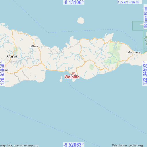
Wolonio GPS coordinates[2]
8° 49' 35.4" South, 121° 38' 34.08" East
| Map corner | latitude | longitude |
|---|---|---|
| Upper-left | -8.13106°, | 120.93968° |
| Center: | -8.8265°, | 121.6428° |
| Lower-right: | -9.52063°, | 122.34593° |
| Map W x H: | 154.5×154.5 km | = 96×96mi |
| max Lat: | 5.88969° ⇑91.8% North |
| Wolonio: | -8.8265° |
| min Lat: | ⇓8.2% South -10.934° |
| min Long | Wolonio | max Long |
| 95.1345° | 121.6428° | 140.9419° |
| W 86.9%⇐ | ⇒13.1% E |
Elevation
Elevation of Wolonio is 104 m = 341 ft, and this is 125.7 m = 412 ft below average elevation for this country.
| Max E: |
3185 m = 10449 ft | 49.4% |
| Avg. | 229.7 m = 754 ft | |
| Wolonio | 104 m = 341 ft | |
Min E: |
-1 m = -3 ft | 50.6% |
See also: Indonesia elevation on elevation.city.
Geographical zone
Wolonio is located in South Torrid zone (between Equator and Tropic of Capricorn). Distance of Equator is 981.4 km =609.8 mi to North.| Distance of | km | miles | from Wolonio |
|---|---|---|---|
| Equator | 981.4 | 609.8 | to North |
| Tropic Capricorn | 1624.5 | 1009.4 | to South |
| Antarctic Circle | 6419.8 | 3989.1 | to South |
| South Pole | 9025.6 | 5608.2 | to South |


Nearby cities:
15 places around Wolonio: (largest is in red/bold)
• Aemura
3.4 km =2.1 mi,  54°
54°
• Ende
2.8 km =1.7 mi,  130°
130°
• Lokoboko
4.2 km =2.6 mi,  79°
79°
• Mautapaga Bawah
3.8 km =2.4 mi,  122°
122°
• Mbomba
2.5 km =1.6 mi,  265°
265°
• Mbongawani
2.3 km =1.4 mi,  174°
174°
• Nuasepu
3.6 km =2.2 mi,  345°
345°
• Onekore
1.5 km =0.9 mi,  138°
138°
• Onewitu
1.5 km =0.9 mi, 171°
• Paupanda Bawah
3.3 km =2.1 mi,  179°
179°
• Potulando
2.5 km =1.6 mi,  155°
155°
• Puuperi
3.6 km =2.2 mi,  9°
9°
• Rukunlima Bawah
2.7 km =1.7 mi, 177°
• Tetandara
3.3 km =2.1 mi,  150°
150°
• Wolowona
3.8 km =2.4 mi,  99°
99°
Sources, notices
• [Note1] Compared only with cities in Indonesia existing in our database
• [Src1] Map data: © OpenStreetMap contributors (CC-BY-SA)
• [Src2] Other city data from geonames.org with taken over terms of usage.
• [Src3] Geographical zone / Annual Mean Temperature by Robert A. Rohde @ Wikipedia
