Doro Oo geodata
Doro Oo (West Nusa Tenggara) is a seat of a fourth-order administrative division; located in Indonesia in Asia/Makassar (GMT+8) time zone. In our database, there are 407 cities with bigger population. Compared to other cities in Indonesia, 88.9% of cities are located further ↑North; 80.2% of cities are located further ←West and 86.4% of cities have higher elevation than Doro Oo. Note1


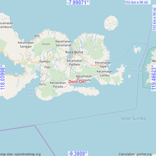
Doro Oo GPS coordinates[2]
8° 41' 11.04" South, 118° 45' 47.16" East
| Map corner | latitude | longitude |
|---|---|---|
| Upper-left | -7.99071°, | 118.05998° |
| Center: | -8.6864°, | 118.7631° |
| Lower-right: | -9.3808°, | 119.46623° |
| Map W x H: | 154.6×154.6 km | = 96.1×96.1mi |
| max Lat: | 5.88969° ⇑88.9% North |
| Doro Oo: | -8.6864° |
| min Lat: | ⇓11.1% South -10.934° |
| min Long | Doro Oo | max Long |
| 95.1345° | 118.7631° | 140.9419° |
| W 80.2%⇐ | ⇒19.8% E |
Elevation
Elevation of Doro Oo is 13 m = 43 ft, and this is 216.7 m = 711 ft below average elevation for this country.
| Max E: |
3185 m = 10449 ft | 86.4% |
| Avg. | 229.7 m = 754 ft | |
| Doro Oo | 13 m = 43 ft | |
Min E: |
-1 m = -3 ft | 13.6% |
See also: Indonesia elevation on elevation.city.
Geographical zone
Doro Oo is located in South Torrid zone (between Equator and Tropic of Capricorn). Distance of Equator is 965.8 km =600.1 mi to North.| Distance of | km | miles | from Doro Oo |
|---|---|---|---|
| Equator | 965.8 | 600.1 | to North |
| Tropic Capricorn | 1640.1 | 1019.1 | to South |
| Antarctic Circle | 6435.3 | 3998.7 | to South |
| South Pole | 9041.2 | 5617.9 | to South |


Nearby cities:
15 places around Doro Oo: (largest is in red/bold)
• Kalodu
8.8 km =5.5 mi,  69°
69°
• Karano
4.4 km =2.7 mi,  237°
237°
• Karumbu
7.5 km =4.7 mi,  97°
97°
• Kuta
11.4 km =7.1 mi,  10°
10°
• Lambitu
10 km =6.2 mi, 5°
• Lantebaru
6.1 km =3.8 mi, 10°
• Lido
7.1 km =4.4 mi,  333°
333°
• Ncera
6.1 km =3.8 mi,  340°
340°
• Ompuboi
8.7 km =5.4 mi,  317°
317°
• Rupe
8.3 km =5.2 mi, 96°
• Simpasai
10.8 km =6.7 mi,  266°
266°
• Sondo
12.6 km =7.8 mi, 238°
• Tangga
8.3 km =5.2 mi,  293°
293°
• Waworada
4.2 km =2.6 mi,  110°
110°
• Waworada
8.5 km =5.3 mi,  282°
282°
Sources, notices
• [Note1] Compared only with cities in Indonesia existing in our database
• [Src1] Map data: © OpenStreetMap contributors (CC-BY-SA)
• [Src2] Other city data from geonames.org with taken over terms of usage.
• [Src3] Geographical zone / Annual Mean Temperature by Robert A. Rohde @ Wikipedia
