Baanfaun geodata
Baanfaun (East Nusa Tenggara) is a seat of a fourth-order administrative division; located in Indonesia in Asia/Makassar (GMT+8) time zone. In our database, there are 407 cities with bigger population. Compared to other cities in Indonesia, 93.7% of cities are located further ↑North; 97% of cities are located further ←West and 69.6% of cities have lower elevation than Baanfaun. Note1


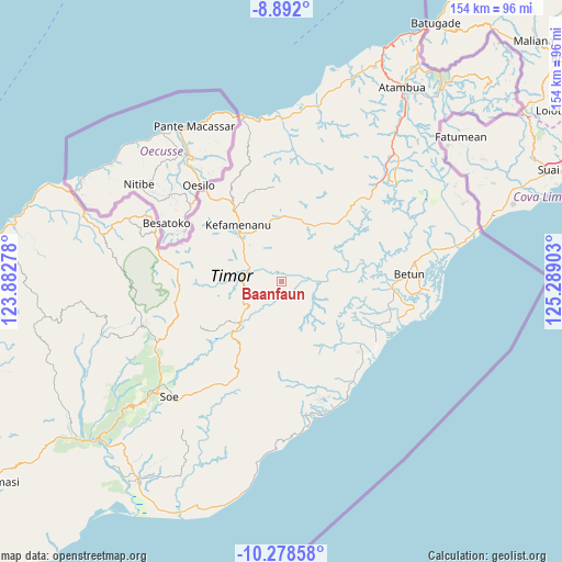
Baanfaun GPS coordinates[2]
9° 35' 9.6" South, 124° 35' 9.24" East
| Map corner | latitude | longitude |
|---|---|---|
| Upper-left | -8.892°, | 123.88278° |
| Center: | -9.586°, | 124.5859° |
| Lower-right: | -10.27858°, | 125.28903° |
| Map W x H: | 154.2×154.2 km | = 95.8×95.8mi |
| max Lat: | 5.88969° ⇑93.7% North |
| Baanfaun: | -9.586° |
| min Lat: | ⇓6.3% South -10.934° |
| min Long | Baanfaun | max Long |
| 95.1345° | 124.5859° | 140.9419° |
| W 97%⇐ | ⇒3% E |
Elevation
Elevation of Baanfaun is 286 m = 938 ft, and this is 56.3 m = 185 ft above average elevation for this country.
| Max E: |
3185 m = 10449 ft | 30.4% |
| Baanfaun | 286 m 938 ft | |
| Avg. | 229.7 m = 754 ft | |
Min E: |
-1 m = -3 ft | 69.6% |
See also: Indonesia elevation on elevation.city.
Geographical zone
Baanfaun is located in South Torrid zone (between Equator and Tropic of Capricorn). Distance of Equator is 1065.9 km =662.3 mi to North.| Distance of | km | miles | from Baanfaun |
|---|---|---|---|
| Equator | 1065.9 | 662.3 | to North |
| Tropic Capricorn | 1540.1 | 957 | to South |
| Antarctic Circle | 6335.3 | 3936.6 | to South |
| South Pole | 8941.2 | 5555.8 | to South |


Nearby cities:
15 places around Baanfaun: (largest is in red/bold)
• Besnam
10.6 km =6.6 mi,  132°
132°
• Biito
7.6 km =4.7 mi,  203°
203°
• Bijeli
10.6 km =6.6 mi,  267°
267°
• Fatualam
10.4 km =6.5 mi,  334°
334°
• Leof
4.3 km =2.7 mi,  76°
76°
• Maurisu
7.8 km =4.8 mi, 80°
• Naiola
9.8 km =6.1 mi,  295°
295°
• Nelabesa
5.1 km =3.2 mi,  153°
153°
• Neob
2.8 km =1.7 mi, 152°
• Nibaaf
6.4 km =4 mi, 270°
• Noemuti
10.2 km =6.3 mi,  281°
281°
• Nularan
9.3 km =5.8 mi,  109°
109°
• Oenak
9.6 km =6 mi,  286°
286°
• Pakaebena
10.2 km =6.3 mi, 277°
• Popnam
7.4 km =4.6 mi,  234°
234°
Sources, notices
• [Note1] Compared only with cities in Indonesia existing in our database
• [Src1] Map data: © OpenStreetMap contributors (CC-BY-SA)
• [Src2] Other city data from geonames.org with taken over terms of usage.
• [Src3] Geographical zone / Annual Mean Temperature by Robert A. Rohde @ Wikipedia
