Banjar Kelodan geodata
Banjar Kelodan (Bali) is a seat of a fourth-order administrative division; located in Indonesia in Asia/Makassar (GMT+8) time zone. In our database, there are 407 cities with bigger population. Compared to other cities in Indonesia, 78.4% of cities are located further ↑North; 75.5% of cities are located further ←West and 66.7% of cities have lower elevation than Banjar Kelodan. Note1


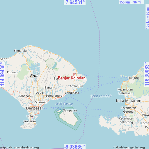
Banjar Kelodan GPS coordinates[2]
8° 20' 29.76" South, 115° 35' 51" East
| Map corner | latitude | longitude |
|---|---|---|
| Upper-left | -7.64531°, | 114.89438° |
| Center: | -8.3416°, | 115.5975° |
| Lower-right: | -9.03665°, | 116.30063° |
| Map W x H: | 154.7×154.7 km | = 96.1×96.1mi |
| max Lat: | 5.88969° ⇑78.4% North |
| Banjar Kelodan: | -8.3416° |
| min Lat: | ⇓21.6% South -10.934° |
| min Long | Banjar Kelodan | max Long |
| 95.1345° | 115.5975° | 140.9419° |
| W 75.5%⇐ | ⇒24.5% E |
Elevation
Elevation of Banjar Kelodan is 247 m = 810 ft, and this is 17.3 m = 57 ft above average elevation for this country.
| Max E: |
3185 m = 10449 ft | 33.3% |
| Banjar Kelodan | 247 m 810 ft | |
| Avg. | 229.7 m = 754 ft | |
Min E: |
-1 m = -3 ft | 66.7% |
See also: Indonesia elevation on elevation.city.
Geographical zone
Banjar Kelodan is located in South Torrid zone (between Equator and Tropic of Capricorn). Distance of Equator is 927.5 km =576.3 mi to North.| Distance of | km | miles | from Banjar Kelodan |
|---|---|---|---|
| Equator | 927.5 | 576.3 | to North |
| Tropic Capricorn | 1678.4 | 1042.9 | to South |
| Antarctic Circle | 6473.7 | 4022.6 | to South |
| South Pole | 9079.6 | 5641.8 | to South |


Nearby cities:
15 places around Banjar Kelodan: (largest is in red/bold)
• Abang
5 km =3.1 mi,  175°
175°
• Banjar Ababi
7.2 km =4.5 mi,  190°
190°
• Banjar Bau Kawan
4.5 km =2.8 mi,  198°
198°
• Banjar Buayang
1.8 km =1.1 mi,  103°
103°
• Banjar Budakeling
10 km =6.2 mi, 196°
• Banjar Dukuh
8.3 km =5.2 mi,  322°
322°
• Banjar Kangkaang
2.4 km =1.5 mi,  136°
136°
• Banjar Kubu
10.2 km =6.3 mi,  343°
343°
• Baturinggit Kaja
11.2 km =7 mi, 340°
• Biaslantang Kaler
3.5 km =2.2 mi,  79°
79°
• Kubu
10.5 km =6.5 mi, 341°
• Penggakrajeng
3 km =1.9 mi,  49°
49°
• Tibulakasasak
9.8 km =6.1 mi,  158°
158°
• Tistagede
4.4 km =2.7 mi, 163°
• Tiyingtali Kelod
8 km =5 mi,  165°
165°
Sources, notices
• [Note1] Compared only with cities in Indonesia existing in our database
• [Src1] Map data: © OpenStreetMap contributors (CC-BY-SA)
• [Src2] Other city data from geonames.org with taken over terms of usage.
• [Src3] Geographical zone / Annual Mean Temperature by Robert A. Rohde @ Wikipedia
